You are here: Home > Network List > TA - USArray Transportable Network (new EarthScope stations) Stations List
> Station W13A Hualapai Mountain Park, Kingman, AZ, USA > Earthquake Result Viewer
W13A Hualapai Mountain Park, Kingman, AZ, USA - Earthquake Result Viewer
| Earthquake location: |
Near West Coast Of Honshu, Japan |
| Earthquake latitude/longitude: |
37.5/138.4 |
| Earthquake time(UTC): |
2007/07/16 (197) 01:13:22 GMT |
| Earthquake Depth: |
12 km |
| Earthquake Magnitude: |
6.5 MB, 6.4 MS, 6.6 MW, 6.5 MW |
| Earthquake Catalog/Contributor: |
WHDF/NEIC |
|
| Network: |
TA USArray Transportable Network (new EarthScope stations) |
| Station: |
W13A Hualapai Mountain Park, Kingman, AZ, USA |
| Lat/Lon: |
35.10 N/113.89 W |
| Elevation: |
1988 m |
|
| Distance: |
81.4 deg |
| Az: |
52.201 deg |
| Baz: |
309.999 deg |
| Ray Param: |
0.047605094 |
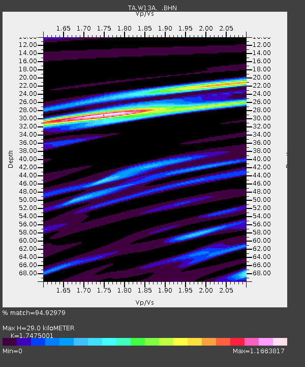
| Estimated Moho Depth: |
29.0 km |
| Estimated Crust Vp/Vs: |
1.75 |
| Assumed Crust Vp: |
6.276 km/s |
| Estimated Crust Vs: |
3.591 km/s |
| Estimated Crust Poisson's Ratio: |
0.26 |
|
| Radial Match: |
94.92979 % |
| Radial Bump: |
395 |
| Transverse Match: |
83.23408 % |
| Transverse Bump: |
400 |
| SOD ConfigId: |
2564 |
| Insert Time: |
2010-03-05 23:20:53.026 +0000 |
| GWidth: |
2.5 |
| Max Bumps: |
400 |
| Tol: |
0.001 |
|

Signal To Noise
| Channel | StoN | STA | LTA |
| TA:W13A: :BHN:20070716T01:25:07.549016Z | 9.333323 | 4.4482942E-7 | 4.766035E-8 |
| TA:W13A: :BHE:20070716T01:25:07.549016Z | 11.162898 | 5.5274535E-7 | 4.9516295E-8 |
| TA:W13A: :BHZ:20070716T01:25:07.549016Z | 35.603188 | 1.7742238E-6 | 4.9833282E-8 |
| Arrivals |
| Ps | 3.5 SECOND |
| PpPs | 12 SECOND |
| PsPs/PpSs | 16 SECOND |


