You are here: Home > Network List > TA - USArray Transportable Network (new EarthScope stations) Stations List
> Station W13A Hualapai Mountain Park, Kingman, AZ, USA > Earthquake Result Viewer
W13A Hualapai Mountain Park, Kingman, AZ, USA - Earthquake Result Viewer
| Earthquake location: |
East Of Kuril Islands |
| Earthquake latitude/longitude: |
46.2/154.5 |
| Earthquake time(UTC): |
2007/01/13 (013) 04:23:21 GMT |
| Earthquake Depth: |
10 km |
| Earthquake Magnitude: |
7.3 MB, 8.2 MS, 8.1 MW, 7.9 MW |
| Earthquake Catalog/Contributor: |
WHDF/NEIC |
|
| Network: |
TA USArray Transportable Network (new EarthScope stations) |
| Station: |
W13A Hualapai Mountain Park, Kingman, AZ, USA |
| Lat/Lon: |
35.10 N/113.89 W |
| Elevation: |
1988 m |
|
| Distance: |
66.7 deg |
| Az: |
63.222 deg |
| Baz: |
310.92 deg |
| Ray Param: |
0.057474263 |
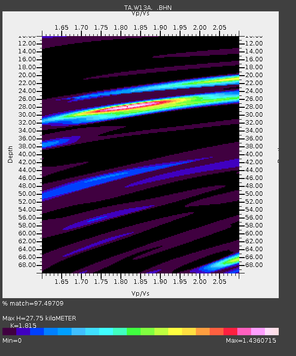
| Estimated Moho Depth: |
27.75 km |
| Estimated Crust Vp/Vs: |
1.82 |
| Assumed Crust Vp: |
6.276 km/s |
| Estimated Crust Vs: |
3.458 km/s |
| Estimated Crust Poisson's Ratio: |
0.28 |
|
| Radial Match: |
97.49709 % |
| Radial Bump: |
301 |
| Transverse Match: |
82.74472 % |
| Transverse Bump: |
400 |
| SOD ConfigId: |
2564 |
| Insert Time: |
2010-03-05 23:20:59.987 +0000 |
| GWidth: |
2.5 |
| Max Bumps: |
400 |
| Tol: |
0.001 |
|
Signal To Noise
| Channel | StoN | STA | LTA |
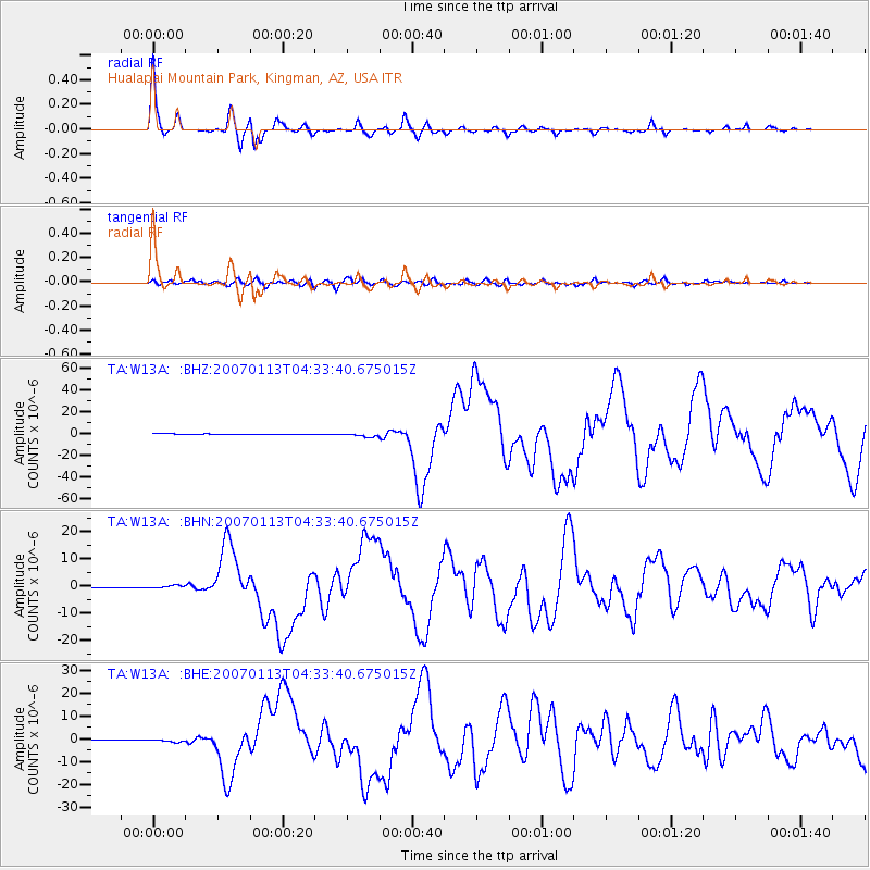
| TA:W13A: :BHN:20070113T04:33:40.675015Z | 5.0511556 | 5.569127E-7 | 1.1025451E-7 |
| TA:W13A: :BHE:20070113T04:33:40.675015Z | 4.4561977 | 7.020279E-7 | 1.5753965E-7 |
| TA:W13A: :BHZ:20070113T04:33:40.675015Z | 9.267192 | 1.8990258E-6 | 2.0491923E-7 |
| Arrivals |
| Ps | 3.7 SECOND |
| PpPs | 12 SECOND |
| PsPs/PpSs | 16 SECOND |


