You are here: Home > Network List > AG - Arkansas Seismic Network Stations List
> Station LCAR Lake Charles,AR > Earthquake Result Viewer
LCAR Lake Charles,AR - Earthquake Result Viewer
| Earthquake location: |
Peru-Brazil Border Region |
| Earthquake latitude/longitude: |
-9.2/-71.3 |
| Earthquake time(UTC): |
2015/11/26 (330) 05:45:18 GMT |
| Earthquake Depth: |
604 km |
| Earthquake Magnitude: |
6.4 MWP |
| Earthquake Catalog/Contributor: |
NEIC PDE/NEIC COMCAT |
|
| Network: |
AG Arkansas Seismic Network |
| Station: |
LCAR Lake Charles,AR |
| Lat/Lon: |
36.07 N/91.15 W |
| Elevation: |
103 m |
|
| Distance: |
48.8 deg |
| Az: |
338.516 deg |
| Baz: |
153.495 deg |
| Ray Param: |
0.06623773 |
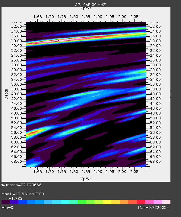
| Estimated Moho Depth: |
17.5 km |
| Estimated Crust Vp/Vs: |
1.74 |
| Assumed Crust Vp: |
6.53 km/s |
| Estimated Crust Vs: |
3.764 km/s |
| Estimated Crust Poisson's Ratio: |
0.25 |
|
| Radial Match: |
87.079666 % |
| Radial Bump: |
305 |
| Transverse Match: |
74.09967 % |
| Transverse Bump: |
400 |
| SOD ConfigId: |
1259291 |
| Insert Time: |
2015-12-10 05:56:30.628 +0000 |
| GWidth: |
2.5 |
| Max Bumps: |
400 |
| Tol: |
0.001 |
|
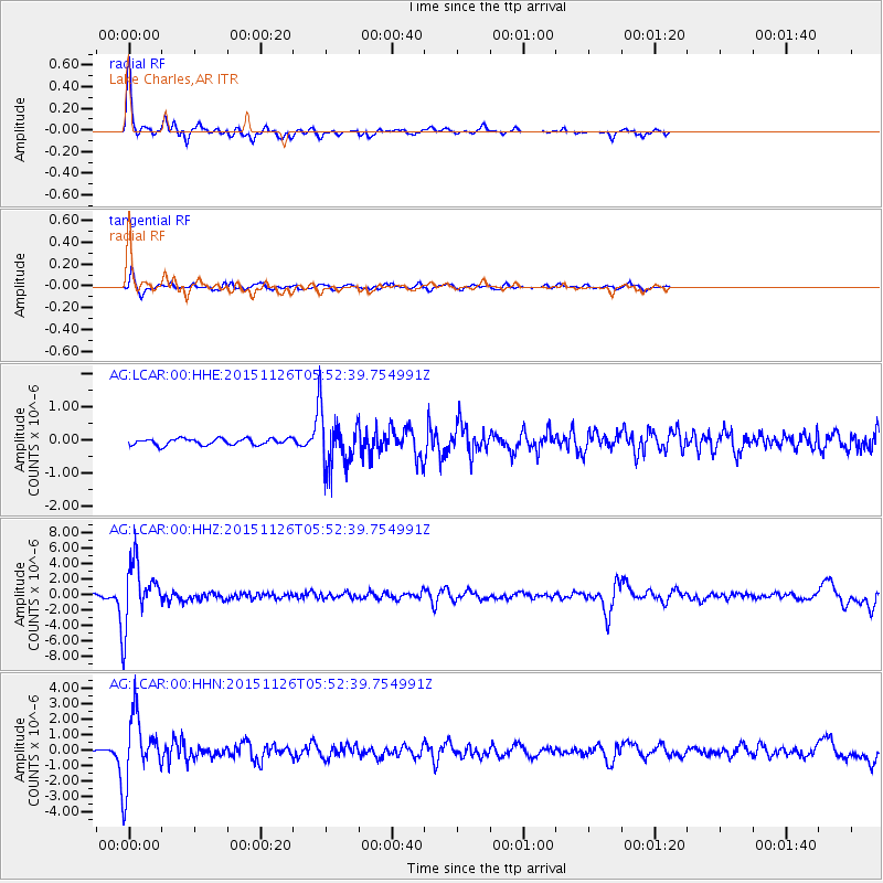
Signal To Noise
| Channel | StoN | STA | LTA |
| AG:LCAR:00:HHZ:20151126T05:52:39.754991Z | 26.224781 | 3.986771E-6 | 1.5202305E-7 |
| AG:LCAR:00:HHN:20151126T05:52:39.754991Z | 18.139477 | 2.1634385E-6 | 1.1926686E-7 |
| AG:LCAR:00:HHE:20151126T05:52:39.754991Z | 8.782011 | 8.388601E-7 | 9.552027E-8 |
| Arrivals |
| Ps | 2.1 SECOND |
| PpPs | 6.9 SECOND |
| PsPs/PpSs | 9.0 SECOND |


