You are here: Home > Network List > TA - USArray Transportable Network (new EarthScope stations) Stations List
> Station H17A Grant Village (NPS), Yellowstone Nt. Park, WY, USA > Earthquake Result Viewer
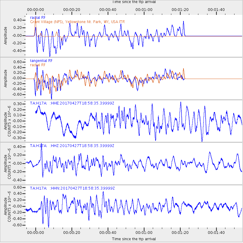
H17A Grant Village (NPS), Yellowstone Nt. Park, WY, USA - Earthquake Result Viewer
*The percent match for this event was below the threshold and hence no stack was calculated.
| Earthquake location: |
Tonga Islands |
| Earthquake latitude/longitude: |
-16.5/-173.7 |
| Earthquake time(UTC): |
2017/04/27 (117) 18:46:42 GMT |
| Earthquake Depth: |
33 km |
| Earthquake Magnitude: |
5.5 mb |
| Earthquake Catalog/Contributor: |
NEIC PDE/us |
|
| Network: |
TA USArray Transportable Network (new EarthScope stations) |
| Station: |
H17A Grant Village (NPS), Yellowstone Nt. Park, WY, USA |
| Lat/Lon: |
44.40 N/110.58 W |
| Elevation: |
2400 m |
|
| Distance: |
83.4 deg |
| Az: |
40.053 deg |
| Baz: |
239.439 deg |
| Ray Param: |
$rayparam |
*The percent match for this event was below the threshold and hence was not used in the summary stack. |
|
| Radial Match: |
47.053516 % |
| Radial Bump: |
400 |
| Transverse Match: |
59.31854 % |
| Transverse Bump: |
400 |
| SOD ConfigId: |
11737051 |
| Insert Time: |
2019-04-27 05:22:59.185 +0000 |
| GWidth: |
2.5 |
| Max Bumps: |
400 |
| Tol: |
0.001 |
|
Signal To Noise
| Channel | StoN | STA | LTA |
| TA:H17A: :HHZ:20170427T18:58:35.39999Z | 2.29964 | 1.6902051E-7 | 7.349868E-8 |
| TA:H17A: :HHN:20170427T18:58:35.39999Z | 3.5951757 | 2.1836846E-7 | 6.0739296E-8 |
| TA:H17A: :HHE:20170427T18:58:35.39999Z | 0.57109505 | 8.833665E-8 | 1.5467941E-7 |
| Arrivals |
| Ps | |
| PpPs | |
| PsPs/PpSs | |


