You are here: Home > Network List > TA - USArray Transportable Network (new EarthScope stations) Stations List
> Station R31K City Hall, Gustavus, AK, USA > Earthquake Result Viewer
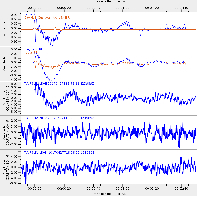
R31K City Hall, Gustavus, AK, USA - Earthquake Result Viewer
*The percent match for this event was below the threshold and hence no stack was calculated.
| Earthquake location: |
Tonga Islands |
| Earthquake latitude/longitude: |
-16.5/-173.7 |
| Earthquake time(UTC): |
2017/04/27 (117) 18:46:42 GMT |
| Earthquake Depth: |
33 km |
| Earthquake Magnitude: |
5.5 mb |
| Earthquake Catalog/Contributor: |
NEIC PDE/us |
|
| Network: |
TA USArray Transportable Network (new EarthScope stations) |
| Station: |
R31K City Hall, Gustavus, AK, USA |
| Lat/Lon: |
58.41 N/135.74 W |
| Elevation: |
15 m |
|
| Distance: |
80.9 deg |
| Az: |
19.127 deg |
| Baz: |
216.669 deg |
| Ray Param: |
$rayparam |
*The percent match for this event was below the threshold and hence was not used in the summary stack. |
|
| Radial Match: |
45.61984 % |
| Radial Bump: |
400 |
| Transverse Match: |
50.473663 % |
| Transverse Bump: |
400 |
| SOD ConfigId: |
11737051 |
| Insert Time: |
2019-04-27 05:23:18.541 +0000 |
| GWidth: |
2.5 |
| Max Bumps: |
400 |
| Tol: |
0.001 |
|
Signal To Noise
| Channel | StoN | STA | LTA |
| TA:R31K: :BHZ:20170427T18:58:22.123989Z | 1.1045507 | 8.015575E-7 | 7.256865E-7 |
| TA:R31K: :BHN:20170427T18:58:22.123989Z | 0.6412317 | 1.59484E-6 | 2.4871508E-6 |
| TA:R31K: :BHE:20170427T18:58:22.123989Z | 0.44351155 | 1.6775483E-6 | 3.7824232E-6 |
| Arrivals |
| Ps | |
| PpPs | |
| PsPs/PpSs | |


