You are here: Home > Network List > TA - USArray Transportable Network (new EarthScope stations) Stations List
> Station S22A 4UR Ranch, Creede, CO, USA > Earthquake Result Viewer
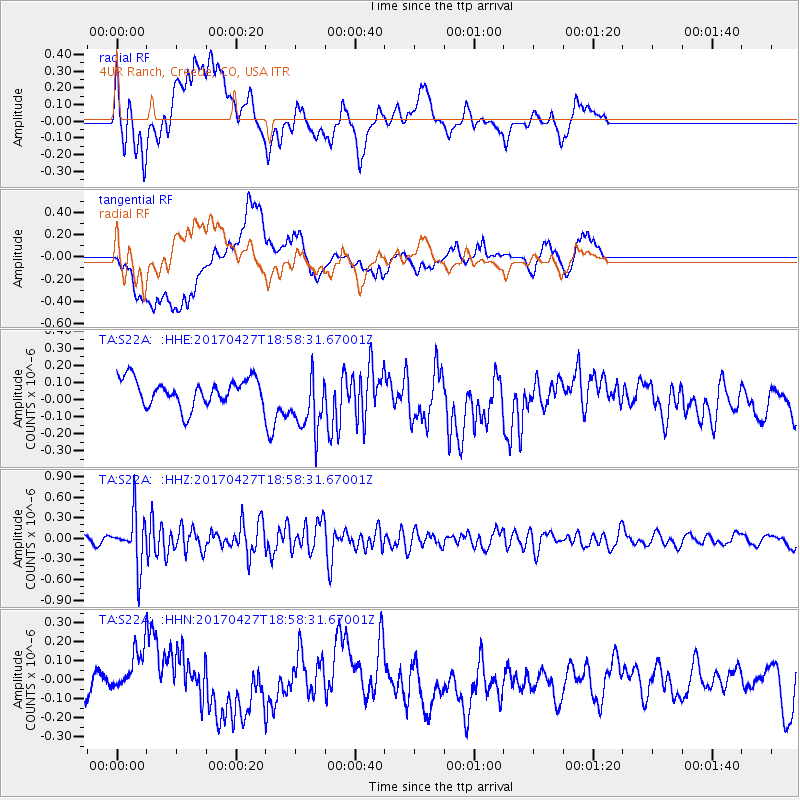
S22A 4UR Ranch, Creede, CO, USA - Earthquake Result Viewer
*The percent match for this event was below the threshold and hence no stack was calculated.
| Earthquake location: |
Tonga Islands |
| Earthquake latitude/longitude: |
-16.5/-173.7 |
| Earthquake time(UTC): |
2017/04/27 (117) 18:46:42 GMT |
| Earthquake Depth: |
33 km |
| Earthquake Magnitude: |
5.5 mb |
| Earthquake Catalog/Contributor: |
NEIC PDE/us |
|
| Network: |
TA USArray Transportable Network (new EarthScope stations) |
| Station: |
S22A 4UR Ranch, Creede, CO, USA |
| Lat/Lon: |
37.75 N/106.83 W |
| Elevation: |
2626 m |
|
| Distance: |
82.7 deg |
| Az: |
47.288 deg |
| Baz: |
242.77 deg |
| Ray Param: |
$rayparam |
*The percent match for this event was below the threshold and hence was not used in the summary stack. |
|
| Radial Match: |
71.47581 % |
| Radial Bump: |
400 |
| Transverse Match: |
69.200325 % |
| Transverse Bump: |
400 |
| SOD ConfigId: |
11737051 |
| Insert Time: |
2019-04-27 05:23:20.012 +0000 |
| GWidth: |
2.5 |
| Max Bumps: |
400 |
| Tol: |
0.001 |
|
Signal To Noise
| Channel | StoN | STA | LTA |
| TA:S22A: :HHZ:20170427T18:58:31.67001Z | 4.730079 | 3.7172742E-7 | 7.8587995E-8 |
| TA:S22A: :HHN:20170427T18:58:31.67001Z | 1.2700813 | 1.2953514E-7 | 1.0198965E-7 |
| TA:S22A: :HHE:20170427T18:58:31.67001Z | 2.3114896 | 1.8010988E-7 | 7.79194E-8 |
| Arrivals |
| Ps | |
| PpPs | |
| PsPs/PpSs | |


