You are here: Home > Network List > TA - USArray Transportable Network (new EarthScope stations) Stations List
> Station W13A Hualapai Mountain Park, Kingman, AZ, USA > Earthquake Result Viewer
W13A Hualapai Mountain Park, Kingman, AZ, USA - Earthquake Result Viewer
| Earthquake location: |
Costa Rica |
| Earthquake latitude/longitude: |
10.2/-84.2 |
| Earthquake time(UTC): |
2009/01/08 (008) 19:21:35 GMT |
| Earthquake Depth: |
14 km |
| Earthquake Magnitude: |
5.7 MB, 6.0 MS, 6.1 MW, 6.1 MW |
| Earthquake Catalog/Contributor: |
WHDF/NEIC |
|
| Network: |
TA USArray Transportable Network (new EarthScope stations) |
| Station: |
W13A Hualapai Mountain Park, Kingman, AZ, USA |
| Lat/Lon: |
35.10 N/113.89 W |
| Elevation: |
1988 m |
|
| Distance: |
36.7 deg |
| Az: |
317.205 deg |
| Baz: |
125.343 deg |
| Ray Param: |
0.07652232 |
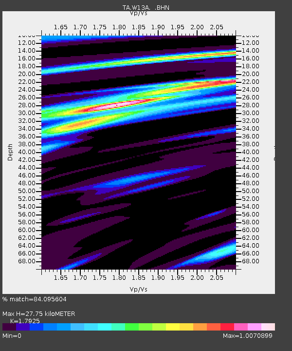
| Estimated Moho Depth: |
27.75 km |
| Estimated Crust Vp/Vs: |
1.79 |
| Assumed Crust Vp: |
6.276 km/s |
| Estimated Crust Vs: |
3.501 km/s |
| Estimated Crust Poisson's Ratio: |
0.27 |
|
| Radial Match: |
84.095604 % |
| Radial Bump: |
242 |
| Transverse Match: |
49.871964 % |
| Transverse Bump: |
400 |
| SOD ConfigId: |
2658 |
| Insert Time: |
2010-03-05 23:21:51.789 +0000 |
| GWidth: |
2.5 |
| Max Bumps: |
400 |
| Tol: |
0.001 |
|

Signal To Noise
| Channel | StoN | STA | LTA |
| TA:W13A: :BHN:20090108T19:28:11.323989Z | 4.022852 | 4.468284E-7 | 1.1107255E-7 |
| TA:W13A: :BHE:20090108T19:28:11.323989Z | 1.9787171 | 1.5573421E-7 | 7.870464E-8 |
| TA:W13A: :BHZ:20090108T19:28:11.323989Z | 2.0870042 | 3.0017733E-7 | 1.4383167E-7 |
| Arrivals |
| Ps | 3.8 SECOND |
| PpPs | 12 SECOND |
| PsPs/PpSs | 15 SECOND |


