You are here: Home > Network List > TA - USArray Transportable Network (new EarthScope stations) Stations List
> Station W13A Hualapai Mountain Park, Kingman, AZ, USA > Earthquake Result Viewer
W13A Hualapai Mountain Park, Kingman, AZ, USA - Earthquake Result Viewer
| Earthquake location: |
Southern Peru |
| Earthquake latitude/longitude: |
-15.6/-73.2 |
| Earthquake time(UTC): |
2006/09/30 (273) 16:26:56 GMT |
| Earthquake Depth: |
107 km |
| Earthquake Magnitude: |
5.6 MB, 6.0 MW, 5.9 MW |
| Earthquake Catalog/Contributor: |
WHDF/NEIC |
|
| Network: |
TA USArray Transportable Network (new EarthScope stations) |
| Station: |
W13A Hualapai Mountain Park, Kingman, AZ, USA |
| Lat/Lon: |
35.10 N/113.89 W |
| Elevation: |
1988 m |
|
| Distance: |
63.5 deg |
| Az: |
323.293 deg |
| Baz: |
135.374 deg |
| Ray Param: |
0.05923335 |
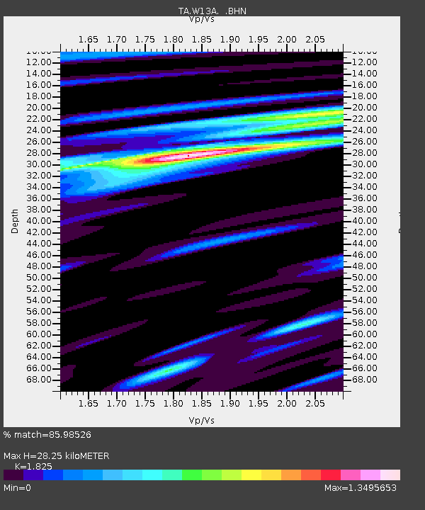
| Estimated Moho Depth: |
28.25 km |
| Estimated Crust Vp/Vs: |
1.83 |
| Assumed Crust Vp: |
6.276 km/s |
| Estimated Crust Vs: |
3.439 km/s |
| Estimated Crust Poisson's Ratio: |
0.29 |
|
| Radial Match: |
85.98526 % |
| Radial Bump: |
400 |
| Transverse Match: |
81.70025 % |
| Transverse Bump: |
389 |
| SOD ConfigId: |
2564 |
| Insert Time: |
2010-03-05 23:22:07.576 +0000 |
| GWidth: |
2.5 |
| Max Bumps: |
400 |
| Tol: |
0.001 |
|
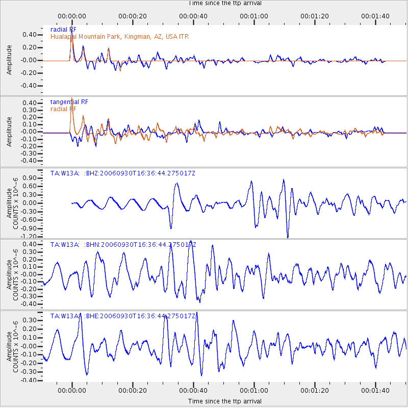
Signal To Noise
| Channel | StoN | STA | LTA |
| TA:W13A: :BHN:20060930T16:36:44.275017Z | 1.133139 | 9.798683E-8 | 8.647379E-8 |
| TA:W13A: :BHE:20060930T16:36:44.275017Z | 1.8018516 | 1.9899386E-7 | 1.10438535E-7 |
| TA:W13A: :BHZ:20060930T16:36:44.275017Z | 3.5520823 | 4.4876023E-7 | 1.2633723E-7 |
| Arrivals |
| Ps | 3.9 SECOND |
| PpPs | 12 SECOND |
| PsPs/PpSs | 16 SECOND |


