You are here: Home > Network List > CI - Caltech Regional Seismic Network Stations List
> Station MWC Mt. Wilson Observatory, Altadena, CA, USA > Earthquake Result Viewer
MWC Mt. Wilson Observatory, Altadena, CA, USA - Earthquake Result Viewer
| Earthquake location: |
Near Coast Of Peru |
| Earthquake latitude/longitude: |
-17.5/-72.1 |
| Earthquake time(UTC): |
2001/07/07 (188) 09:38:43 GMT |
| Earthquake Depth: |
33 km |
| Earthquake Magnitude: |
6.6 MB, 7.3 MS, 7.6 MW, 7.5 ME |
| Earthquake Catalog/Contributor: |
WHDF/NEIC |
|
| Network: |
CI Caltech Regional Seismic Network |
| Station: |
MWC Mt. Wilson Observatory, Altadena, CA, USA |
| Lat/Lon: |
34.22 N/118.06 W |
| Elevation: |
1725 m |
|
| Distance: |
67.6 deg |
| Az: |
319.861 deg |
| Baz: |
132.076 deg |
| Ray Param: |
0.056821957 |
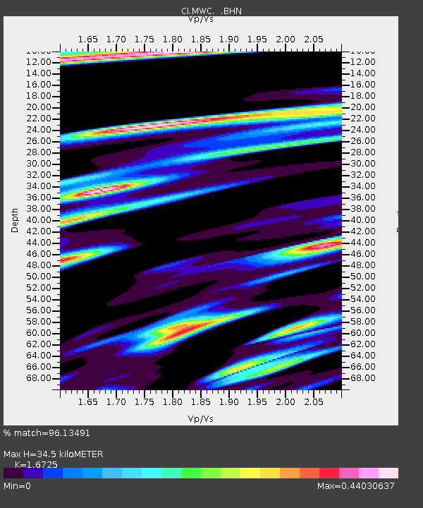
| Estimated Moho Depth: |
34.5 km |
| Estimated Crust Vp/Vs: |
1.67 |
| Assumed Crust Vp: |
6.1 km/s |
| Estimated Crust Vs: |
3.647 km/s |
| Estimated Crust Poisson's Ratio: |
0.22 |
|
| Radial Match: |
96.13491 % |
| Radial Bump: |
323 |
| Transverse Match: |
91.663956 % |
| Transverse Bump: |
400 |
| SOD ConfigId: |
3770 |
| Insert Time: |
2010-02-26 01:08:08.191 +0000 |
| GWidth: |
2.5 |
| Max Bumps: |
400 |
| Tol: |
0.001 |
|

Signal To Noise
| Channel | StoN | STA | LTA |
| CI:MWC: :BHN:20010707T09:49:05.811016Z | 0.5770269 | 1.547388E-7 | 2.6816565E-7 |
| CI:MWC: :BHE:20010707T09:49:05.811016Z | 0.52083194 | 1.14296334E-7 | 2.1944955E-7 |
| CI:MWC: :BHZ:20010707T09:49:05.811016Z | 1.8947039 | 3.7355855E-7 | 1.9715934E-7 |
| Arrivals |
| Ps | 3.9 SECOND |
| PpPs | 15 SECOND |
| PsPs/PpSs | 19 SECOND |


