You are here: Home > Network List > TA - USArray Transportable Network (new EarthScope stations) Stations List
> Station W13A Hualapai Mountain Park, Kingman, AZ, USA > Earthquake Result Viewer
W13A Hualapai Mountain Park, Kingman, AZ, USA - Earthquake Result Viewer

| Earthquake location: |
Eastern Siberia, Russia |
| Earthquake latitude/longitude: |
60.8/165.7 |
| Earthquake time(UTC): |
2006/05/22 (142) 11:12:00 GMT |
| Earthquake Depth: |
16 km |
| Earthquake Magnitude: |
6.0 MB, 6.7 MS, 6.6 MW, 6.5 MW |
| Earthquake Catalog/Contributor: |
WHDF/NEIC |
|
| Network: |
TA USArray Transportable Network (new EarthScope stations) |
| Station: |
W13A Hualapai Mountain Park, Kingman, AZ, USA |
| Lat/Lon: |
35.10 N/113.89 W |
| Elevation: |
1988 m |
|
| Distance: |
55.5 deg |
| Az: |
78.699 deg |
| Baz: |
324.057 deg |
| Ray Param: |
0.064717785 |
| Estimated Moho Depth: |
29.25 km |
| Estimated Crust Vp/Vs: |
1.78 |
| Assumed Crust Vp: |
6.276 km/s |
| Estimated Crust Vs: |
3.531 km/s |
| Estimated Crust Poisson's Ratio: |
0.27 |
|
| Radial Match: |
86.6707 % |
| Radial Bump: |
400 |
| Transverse Match: |
61.47148 % |
| Transverse Bump: |
400 |
| SOD ConfigId: |
5423 |
| Insert Time: |
2010-03-05 23:22:18.513 +0000 |
| GWidth: |
2.5 |
| Max Bumps: |
400 |
| Tol: |
0.001 |
|
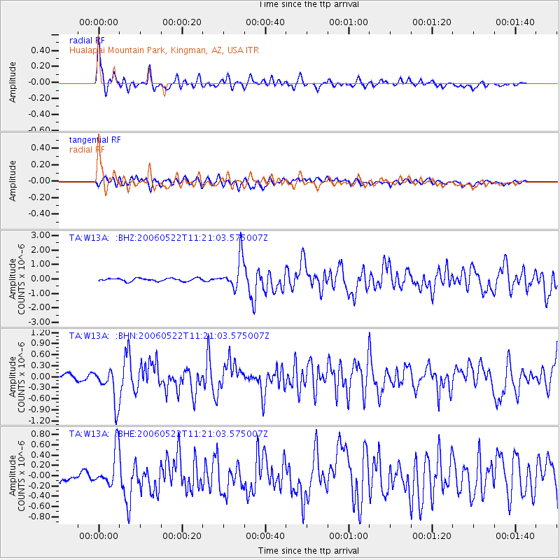
Signal To Noise
| Channel | StoN | STA | LTA |
| TA:W13A: :BHN:20060522T11:21:03.575007Z | 4.8960223 | 5.180934E-7 | 1.0581925E-7 |
| TA:W13A: :BHE:20060522T11:21:03.575007Z | 3.4227095 | 3.648941E-7 | 1.0660972E-7 |
| TA:W13A: :BHZ:20060522T11:21:03.575007Z | 11.124146 | 1.1033595E-6 | 9.9185996E-8 |
| Arrivals |
| Ps | 3.8 SECOND |
| PpPs | 12 SECOND |
| PsPs/PpSs | 16 SECOND |


