You are here: Home > Network List > TA - USArray Transportable Network (new EarthScope stations) Stations List
> Station W13A Hualapai Mountain Park, Kingman, AZ, USA > Earthquake Result Viewer
W13A Hualapai Mountain Park, Kingman, AZ, USA - Earthquake Result Viewer

| Earthquake location: |
New Britain Region, P.N.G. |
| Earthquake latitude/longitude: |
-5.9/151.0 |
| Earthquake time(UTC): |
2006/10/17 (290) 01:25:12 GMT |
| Earthquake Depth: |
32 km |
| Earthquake Magnitude: |
6.4 MB, 6.9 MS, 6.7 MW, 6.6 MW |
| Earthquake Catalog/Contributor: |
WHDF/NEIC |
|
| Network: |
TA USArray Transportable Network (new EarthScope stations) |
| Station: |
W13A Hualapai Mountain Park, Kingman, AZ, USA |
| Lat/Lon: |
35.10 N/113.89 W |
| Elevation: |
1988 m |
|
| Distance: |
97.5 deg |
| Az: |
55.468 deg |
| Baz: |
268.12 deg |
| Ray Param: |
0.04016776 |
| Estimated Moho Depth: |
26.75 km |
| Estimated Crust Vp/Vs: |
1.89 |
| Assumed Crust Vp: |
6.276 km/s |
| Estimated Crust Vs: |
3.325 km/s |
| Estimated Crust Poisson's Ratio: |
0.30 |
|
| Radial Match: |
89.70414 % |
| Radial Bump: |
400 |
| Transverse Match: |
58.220737 % |
| Transverse Bump: |
400 |
| SOD ConfigId: |
2665 |
| Insert Time: |
2010-03-05 23:22:33.472 +0000 |
| GWidth: |
2.5 |
| Max Bumps: |
400 |
| Tol: |
0.001 |
|
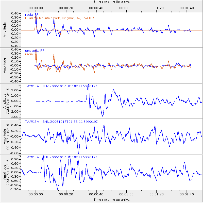
Signal To Noise
| Channel | StoN | STA | LTA |
| TA:W13A: :BHN:20061017T01:38:11.599019Z | 0.524804 | 6.319763E-8 | 1.204214E-7 |
| TA:W13A: :BHE:20061017T01:38:11.599019Z | 2.7793756 | 3.876079E-7 | 1.3945863E-7 |
| TA:W13A: :BHZ:20061017T01:38:11.599019Z | 15.086633 | 1.1569203E-6 | 7.6685126E-8 |
| Arrivals |
| Ps | 3.8 SECOND |
| PpPs | 12 SECOND |
| PsPs/PpSs | 16 SECOND |


