You are here: Home > Network List > TA - USArray Transportable Network (new EarthScope stations) Stations List
> Station W13A Hualapai Mountain Park, Kingman, AZ, USA > Earthquake Result Viewer
W13A Hualapai Mountain Park, Kingman, AZ, USA - Earthquake Result Viewer

| Earthquake location: |
Eastern Siberia, Russia |
| Earthquake latitude/longitude: |
60.5/165.8 |
| Earthquake time(UTC): |
2006/04/21 (111) 04:32:43 GMT |
| Earthquake Depth: |
9.0 km |
| Earthquake Magnitude: |
6.3 MB, 5.6 MS, 6.1 MW, 6.1 ME |
| Earthquake Catalog/Contributor: |
WHDF/NEIC |
|
| Network: |
TA USArray Transportable Network (new EarthScope stations) |
| Station: |
W13A Hualapai Mountain Park, Kingman, AZ, USA |
| Lat/Lon: |
35.10 N/113.89 W |
| Elevation: |
1988 m |
|
| Distance: |
55.5 deg |
| Az: |
78.6 deg |
| Baz: |
323.758 deg |
| Ray Param: |
0.06472988 |
| Estimated Moho Depth: |
29.0 km |
| Estimated Crust Vp/Vs: |
1.83 |
| Assumed Crust Vp: |
6.276 km/s |
| Estimated Crust Vs: |
3.439 km/s |
| Estimated Crust Poisson's Ratio: |
0.29 |
|
| Radial Match: |
83.1384 % |
| Radial Bump: |
400 |
| Transverse Match: |
78.90958 % |
| Transverse Bump: |
400 |
| SOD ConfigId: |
2669 |
| Insert Time: |
2010-03-05 23:22:59.725 +0000 |
| GWidth: |
2.5 |
| Max Bumps: |
400 |
| Tol: |
0.001 |
|
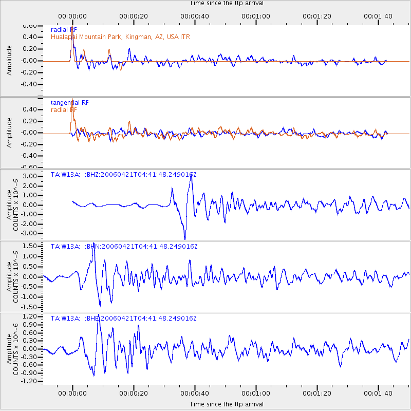
Signal To Noise
| Channel | StoN | STA | LTA |
| TA:W13A: :BHN:20060421T04:41:48.249016Z | 2.2599354 | 2.8565208E-7 | 1.2639833E-7 |
| TA:W13A: :BHE:20060421T04:41:48.249016Z | 2.654152 | 2.2187956E-7 | 8.359716E-8 |
| TA:W13A: :BHZ:20060421T04:41:48.249016Z | 4.289146 | 5.918395E-7 | 1.379854E-7 |
| Arrivals |
| Ps | 4.0 SECOND |
| PpPs | 12 SECOND |
| PsPs/PpSs | 16 SECOND |


