You are here: Home > Network List > TA - USArray Transportable Network (new EarthScope stations) Stations List
> Station 833A Chaparral WMA, Artesia Wells, TX, USA > Earthquake Result Viewer
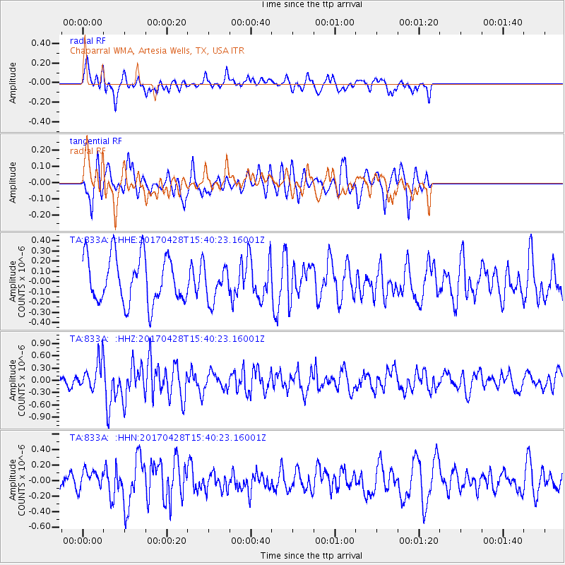
833A Chaparral WMA, Artesia Wells, TX, USA - Earthquake Result Viewer
*The percent match for this event was below the threshold and hence no stack was calculated.
| Earthquake location: |
Near Coast Of Central Chile |
| Earthquake latitude/longitude: |
-33.2/-72.0 |
| Earthquake time(UTC): |
2017/04/28 (118) 15:30:05 GMT |
| Earthquake Depth: |
20 km |
| Earthquake Magnitude: |
5.9 Mww |
| Earthquake Catalog/Contributor: |
NEIC PDE/us |
|
| Network: |
TA USArray Transportable Network (new EarthScope stations) |
| Station: |
833A Chaparral WMA, Artesia Wells, TX, USA |
| Lat/Lon: |
28.32 N/99.39 W |
| Elevation: |
171 m |
|
| Distance: |
66.5 deg |
| Az: |
333.75 deg |
| Baz: |
155.14 deg |
| Ray Param: |
$rayparam |
*The percent match for this event was below the threshold and hence was not used in the summary stack. |
|
| Radial Match: |
58.48315 % |
| Radial Bump: |
400 |
| Transverse Match: |
70.08031 % |
| Transverse Bump: |
400 |
| SOD ConfigId: |
11737051 |
| Insert Time: |
2019-04-27 05:33:58.554 +0000 |
| GWidth: |
2.5 |
| Max Bumps: |
400 |
| Tol: |
0.001 |
|
Signal To Noise
| Channel | StoN | STA | LTA |
| TA:833A: :HHZ:20170428T15:40:23.16001Z | 3.4011161 | 3.7009156E-7 | 1.0881474E-7 |
| TA:833A: :HHN:20170428T15:40:23.16001Z | 1.2049056 | 1.14333226E-7 | 9.488977E-8 |
| TA:833A: :HHE:20170428T15:40:23.16001Z | 0.8036715 | 1.8196639E-7 | 2.2641885E-7 |
| Arrivals |
| Ps | |
| PpPs | |
| PsPs/PpSs | |


