You are here: Home > Network List > GS - US Geological Survey Networks Stations List
> Station DEC12 Decatur Surface Seismic Site, Decatur, IL, USA > Earthquake Result Viewer
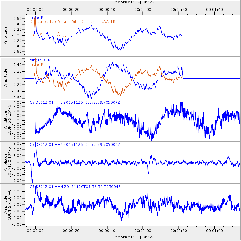
DEC12 Decatur Surface Seismic Site, Decatur, IL, USA - Earthquake Result Viewer
*The percent match for this event was below the threshold and hence no stack was calculated.
| Earthquake location: |
Peru-Brazil Border Region |
| Earthquake latitude/longitude: |
-9.2/-71.3 |
| Earthquake time(UTC): |
2015/11/26 (330) 05:45:18 GMT |
| Earthquake Depth: |
604 km |
| Earthquake Magnitude: |
6.4 MWP |
| Earthquake Catalog/Contributor: |
NEIC PDE/NEIC COMCAT |
|
| Network: |
GS US Geological Survey Networks |
| Station: |
DEC12 Decatur Surface Seismic Site, Decatur, IL, USA |
| Lat/Lon: |
39.91 N/88.91 W |
| Elevation: |
208 m |
|
| Distance: |
51.5 deg |
| Az: |
342.687 deg |
| Baz: |
157.546 deg |
| Ray Param: |
$rayparam |
*The percent match for this event was below the threshold and hence was not used in the summary stack. |
|
| Radial Match: |
56.636925 % |
| Radial Bump: |
400 |
| Transverse Match: |
59.563004 % |
| Transverse Bump: |
400 |
| SOD ConfigId: |
1259291 |
| Insert Time: |
2015-12-10 05:59:10.564 +0000 |
| GWidth: |
2.5 |
| Max Bumps: |
400 |
| Tol: |
0.001 |
|
Signal To Noise
| Channel | StoN | STA | LTA |
| GS:DEC12:01:HHZ:20151126T05:52:59.705004Z | 14.844898 | 3.4511772E-6 | 2.3248238E-7 |
| GS:DEC12:01:HHN:20151126T05:52:59.705004Z | 2.9435441 | 3.597337E-6 | 1.2221107E-6 |
| GS:DEC12:01:HHE:20151126T05:52:59.705004Z | 1.0397322 | 1.5985097E-6 | 1.5374245E-6 |
| Arrivals |
| Ps | |
| PpPs | |
| PsPs/PpSs | |


