You are here: Home > Network List > UW - Pacific Northwest Regional Seismic Network Stations List
> Station UMAT Pilot Rock, OR, USA > Earthquake Result Viewer
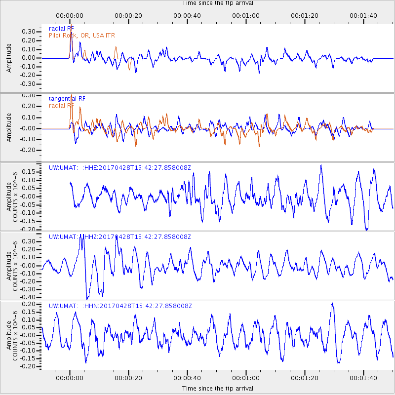
UMAT Pilot Rock, OR, USA - Earthquake Result Viewer
*The percent match for this event was below the threshold and hence no stack was calculated.
| Earthquake location: |
Near Coast Of Central Chile |
| Earthquake latitude/longitude: |
-33.2/-72.0 |
| Earthquake time(UTC): |
2017/04/28 (118) 15:30:05 GMT |
| Earthquake Depth: |
20 km |
| Earthquake Magnitude: |
5.9 Mww |
| Earthquake Catalog/Contributor: |
NEIC PDE/us |
|
| Network: |
UW Pacific Northwest Regional Seismic Network |
| Station: |
UMAT Pilot Rock, OR, USA |
| Lat/Lon: |
45.29 N/118.96 W |
| Elevation: |
1318 m |
|
| Distance: |
89.0 deg |
| Az: |
328.934 deg |
| Baz: |
142.223 deg |
| Ray Param: |
$rayparam |
*The percent match for this event was below the threshold and hence was not used in the summary stack. |
|
| Radial Match: |
63.425262 % |
| Radial Bump: |
400 |
| Transverse Match: |
60.45557 % |
| Transverse Bump: |
400 |
| SOD ConfigId: |
11737051 |
| Insert Time: |
2019-04-27 05:35:00.435 +0000 |
| GWidth: |
2.5 |
| Max Bumps: |
400 |
| Tol: |
0.001 |
|
Signal To Noise
| Channel | StoN | STA | LTA |
| UW:UMAT: :HHZ:20170428T15:42:27.858008Z | 2.3645878 | 1.9248955E-7 | 8.140512E-8 |
| UW:UMAT: :HHN:20170428T15:42:27.858008Z | 1.7644211 | 8.781741E-8 | 4.977123E-8 |
| UW:UMAT: :HHE:20170428T15:42:27.858008Z | 0.9075049 | 3.8307604E-8 | 4.2212008E-8 |
| Arrivals |
| Ps | |
| PpPs | |
| PsPs/PpSs | |


