You are here: Home > Network List > CN - Canadian National Seismograph Network Stations List
> Station VIMO VICTOR MINE, ON > Earthquake Result Viewer
VIMO VICTOR MINE, ON - Earthquake Result Viewer
| Earthquake location: |
Near Coast Of Central Chile |
| Earthquake latitude/longitude: |
-33.1/-71.8 |
| Earthquake time(UTC): |
2017/04/28 (118) 16:05:55 GMT |
| Earthquake Depth: |
14 km |
| Earthquake Magnitude: |
5.7 Mww |
| Earthquake Catalog/Contributor: |
NEIC PDE/us |
|
| Network: |
CN Canadian National Seismograph Network |
| Station: |
VIMO VICTOR MINE, ON |
| Lat/Lon: |
52.82 N/83.74 W |
| Elevation: |
78 m |
|
| Distance: |
86.2 deg |
| Az: |
352.782 deg |
| Baz: |
169.996 deg |
| Ray Param: |
0.044208374 |
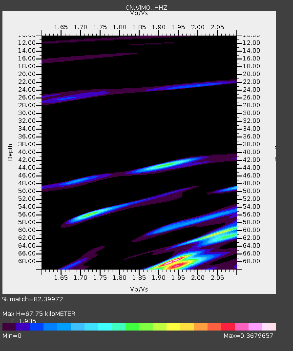
| Estimated Moho Depth: |
67.75 km |
| Estimated Crust Vp/Vs: |
1.93 |
| Assumed Crust Vp: |
6.459 km/s |
| Estimated Crust Vs: |
3.338 km/s |
| Estimated Crust Poisson's Ratio: |
0.32 |
|
| Radial Match: |
82.39972 % |
| Radial Bump: |
366 |
| Transverse Match: |
59.24769 % |
| Transverse Bump: |
400 |
| SOD ConfigId: |
11737051 |
| Insert Time: |
2019-04-27 05:46:49.501 +0000 |
| GWidth: |
2.5 |
| Max Bumps: |
400 |
| Tol: |
0.001 |
|

Signal To Noise
| Channel | StoN | STA | LTA |
| CN:VIMO: :HHZ:20170428T16:18:04.64999Z | 5.08897 | 8.002406E-7 | 1.5725001E-7 |
| CN:VIMO: :HHN:20170428T16:18:04.64999Z | 3.2373154 | 4.6690985E-7 | 1.4422749E-7 |
| CN:VIMO: :HHE:20170428T16:18:04.64999Z | 1.0369139 | 1.12164216E-7 | 1.0817121E-7 |
| Arrivals |
| Ps | 10 SECOND |
| PpPs | 30 SECOND |
| PsPs/PpSs | 40 SECOND |


