You are here: Home > Network List > IU - Global Seismograph Network (GSN - IRIS/USGS) Stations List
> Station TSUM Tsumeb, Namibia > Earthquake Result Viewer
TSUM Tsumeb, Namibia - Earthquake Result Viewer
| Earthquake location: |
Peru-Brazil Border Region |
| Earthquake latitude/longitude: |
-9.2/-71.3 |
| Earthquake time(UTC): |
2015/11/26 (330) 05:45:18 GMT |
| Earthquake Depth: |
604 km |
| Earthquake Magnitude: |
6.4 MWP |
| Earthquake Catalog/Contributor: |
NEIC PDE/NEIC COMCAT |
|
| Network: |
IU Global Seismograph Network (GSN - IRIS/USGS) |
| Station: |
TSUM Tsumeb, Namibia |
| Lat/Lon: |
19.20 S/17.58 E |
| Elevation: |
1260 m |
|
| Distance: |
85.9 deg |
| Az: |
108.696 deg |
| Baz: |
261.692 deg |
| Ray Param: |
0.042644035 |
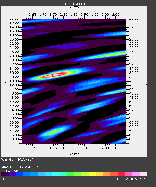
| Estimated Moho Depth: |
37.0 km |
| Estimated Crust Vp/Vs: |
1.75 |
| Assumed Crust Vp: |
6.51 km/s |
| Estimated Crust Vs: |
3.731 km/s |
| Estimated Crust Poisson's Ratio: |
0.26 |
|
| Radial Match: |
93.37204 % |
| Radial Bump: |
387 |
| Transverse Match: |
87.111336 % |
| Transverse Bump: |
400 |
| SOD ConfigId: |
1259291 |
| Insert Time: |
2015-12-10 06:01:39.796 +0000 |
| GWidth: |
2.5 |
| Max Bumps: |
400 |
| Tol: |
0.001 |
|

Signal To Noise
| Channel | StoN | STA | LTA |
| IU:TSUM:00:BHZ:20151126T05:56:25.018999Z | 38.427544 | 5.15395E-6 | 1.3412125E-7 |
| IU:TSUM:00:BH1:20151126T05:56:25.018999Z | 7.8408856 | 8.1661733E-7 | 1.0414861E-7 |
| IU:TSUM:00:BH2:20151126T05:56:25.018999Z | 15.056661 | 1.8356346E-6 | 1.2191512E-7 |
| Arrivals |
| Ps | 4.3 SECOND |
| PpPs | 15 SECOND |
| PsPs/PpSs | 20 SECOND |


