You are here: Home > Network List > N4 - Central and EAstern US Network Stations List
> Station T42B Van Buren, MO, USA > Earthquake Result Viewer
T42B Van Buren, MO, USA - Earthquake Result Viewer
| Earthquake location: |
Near Coast Of Central Chile |
| Earthquake latitude/longitude: |
-33.1/-71.8 |
| Earthquake time(UTC): |
2017/04/28 (118) 16:05:55 GMT |
| Earthquake Depth: |
14 km |
| Earthquake Magnitude: |
5.7 Mww |
| Earthquake Catalog/Contributor: |
NEIC PDE/us |
|
| Network: |
N4 Central and EAstern US Network |
| Station: |
T42B Van Buren, MO, USA |
| Lat/Lon: |
37.03 N/91.09 W |
| Elevation: |
165 m |
|
| Distance: |
72.1 deg |
| Az: |
343.886 deg |
| Baz: |
163.078 deg |
| Ray Param: |
0.053897038 |
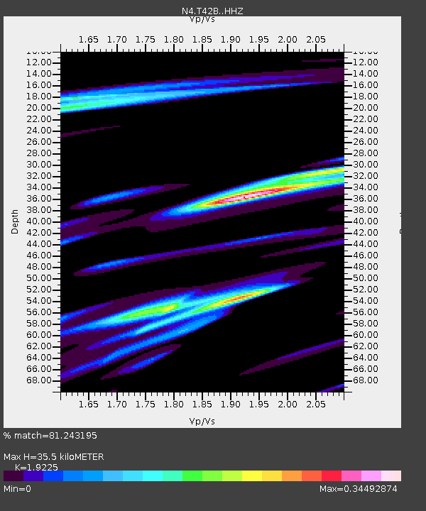
| Estimated Moho Depth: |
35.5 km |
| Estimated Crust Vp/Vs: |
1.92 |
| Assumed Crust Vp: |
6.53 km/s |
| Estimated Crust Vs: |
3.397 km/s |
| Estimated Crust Poisson's Ratio: |
0.31 |
|
| Radial Match: |
81.243195 % |
| Radial Bump: |
293 |
| Transverse Match: |
67.44329 % |
| Transverse Bump: |
400 |
| SOD ConfigId: |
11737051 |
| Insert Time: |
2019-04-27 05:49:14.622 +0000 |
| GWidth: |
2.5 |
| Max Bumps: |
400 |
| Tol: |
0.001 |
|

Signal To Noise
| Channel | StoN | STA | LTA |
| N4:T42B: :HHZ:20170428T16:16:47.740017Z | 3.9351544 | 6.630867E-7 | 1.6850335E-7 |
| N4:T42B: :HHN:20170428T16:16:47.740017Z | 2.177905 | 2.806468E-7 | 1.2886089E-7 |
| N4:T42B: :HHE:20170428T16:16:47.740017Z | 1.9602817 | 2.137822E-7 | 1.0905687E-7 |
| Arrivals |
| Ps | 5.2 SECOND |
| PpPs | 15 SECOND |
| PsPs/PpSs | 21 SECOND |


