You are here: Home > Network List > NE - New England Seismic Network Stations List
> Station QUA2 Belchertown, MA, USA > Earthquake Result Viewer
QUA2 Belchertown, MA, USA - Earthquake Result Viewer
| Earthquake location: |
Peru-Brazil Border Region |
| Earthquake latitude/longitude: |
-9.2/-71.3 |
| Earthquake time(UTC): |
2015/11/26 (330) 05:45:18 GMT |
| Earthquake Depth: |
604 km |
| Earthquake Magnitude: |
6.4 MWP |
| Earthquake Catalog/Contributor: |
NEIC PDE/NEIC COMCAT |
|
| Network: |
NE New England Seismic Network |
| Station: |
QUA2 Belchertown, MA, USA |
| Lat/Lon: |
42.28 N/72.35 W |
| Elevation: |
168 m |
|
| Distance: |
51.3 deg |
| Az: |
358.971 deg |
| Baz: |
178.631 deg |
| Ray Param: |
0.06473012 |
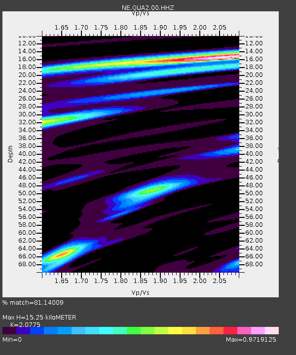
| Estimated Moho Depth: |
15.25 km |
| Estimated Crust Vp/Vs: |
2.08 |
| Assumed Crust Vp: |
6.419 km/s |
| Estimated Crust Vs: |
3.09 km/s |
| Estimated Crust Poisson's Ratio: |
0.35 |
|
| Radial Match: |
81.14009 % |
| Radial Bump: |
280 |
| Transverse Match: |
71.69948 % |
| Transverse Bump: |
400 |
| SOD ConfigId: |
1259291 |
| Insert Time: |
2015-12-10 06:03:04.293 +0000 |
| GWidth: |
2.5 |
| Max Bumps: |
400 |
| Tol: |
0.001 |
|

Signal To Noise
| Channel | StoN | STA | LTA |
| NE:QUA2:00:HHZ:20151126T05:52:57.679003Z | 14.376535 | 3.344849E-6 | 2.326603E-7 |
| NE:QUA2:00:HH1:20151126T05:52:57.679003Z | 9.532801 | 1.948369E-6 | 2.0438577E-7 |
| NE:QUA2:00:HH2:20151126T05:52:57.679003Z | 1.8536593 | 4.1529674E-7 | 2.2404159E-7 |
| Arrivals |
| Ps | 2.7 SECOND |
| PpPs | 7.0 SECOND |
| PsPs/PpSs | 9.7 SECOND |


