You are here: Home > Network List > TA - USArray Transportable Network (new EarthScope stations) Stations List
> Station 229A Bryant Ranch, Stanton, TX, USA > Earthquake Result Viewer
229A Bryant Ranch, Stanton, TX, USA - Earthquake Result Viewer
| Earthquake location: |
Southeast Of Honshu, Japan |
| Earthquake latitude/longitude: |
32.8/140.4 |
| Earthquake time(UTC): |
2009/08/12 (224) 22:48:51 GMT |
| Earthquake Depth: |
53 km |
| Earthquake Magnitude: |
6.2 MB, 6.6 MW, 6.6 MW |
| Earthquake Catalog/Contributor: |
WHDF/NEIC |
|
| Network: |
TA USArray Transportable Network (new EarthScope stations) |
| Station: |
229A Bryant Ranch, Stanton, TX, USA |
| Lat/Lon: |
31.97 N/101.81 W |
| Elevation: |
804 m |
|
| Distance: |
92.8 deg |
| Az: |
48.834 deg |
| Baz: |
311.773 deg |
| Ray Param: |
0.041356184 |
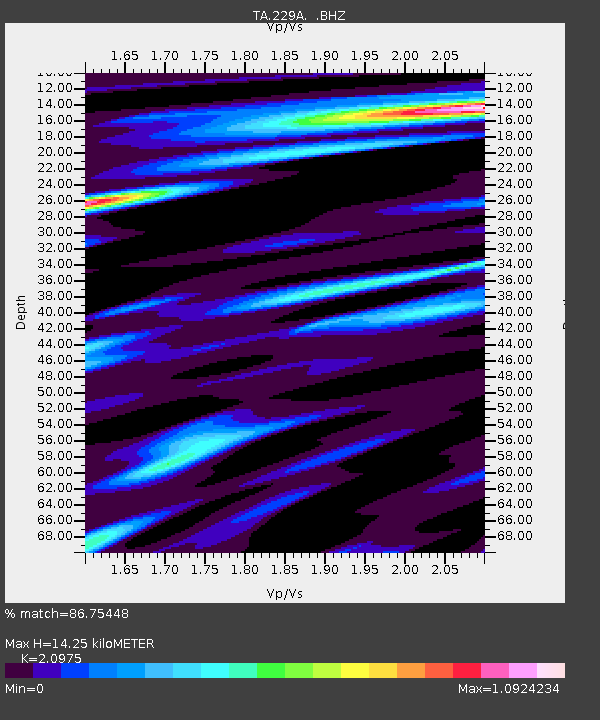
| Estimated Moho Depth: |
14.25 km |
| Estimated Crust Vp/Vs: |
2.10 |
| Assumed Crust Vp: |
6.38 km/s |
| Estimated Crust Vs: |
3.042 km/s |
| Estimated Crust Poisson's Ratio: |
0.35 |
|
| Radial Match: |
86.75448 % |
| Radial Bump: |
400 |
| Transverse Match: |
74.70425 % |
| Transverse Bump: |
400 |
| SOD ConfigId: |
2622 |
| Insert Time: |
2010-03-05 23:25:26.297 +0000 |
| GWidth: |
2.5 |
| Max Bumps: |
400 |
| Tol: |
0.001 |
|

Signal To Noise
| Channel | StoN | STA | LTA |
| TA:229A: :BHZ:20090812T23:01:27.050005Z | 24.92058 | 1.7475908E-6 | 7.012641E-8 |
| TA:229A: :BHN:20090812T23:01:27.050005Z | 3.9538765 | 3.485464E-7 | 8.815308E-8 |
| TA:229A: :BHE:20090812T23:01:27.050005Z | 3.436806 | 3.2028197E-7 | 9.319176E-8 |
| Arrivals |
| Ps | 2.5 SECOND |
| PpPs | 6.8 SECOND |
| PsPs/PpSs | 9.3 SECOND |


