You are here: Home > Network List > TA - USArray Transportable Network (new EarthScope stations) Stations List
> Station 229A Bryant Ranch, Stanton, TX, USA > Earthquake Result Viewer
229A Bryant Ranch, Stanton, TX, USA - Earthquake Result Viewer
| Earthquake location: |
Kuril Islands |
| Earthquake latitude/longitude: |
46.0/151.5 |
| Earthquake time(UTC): |
2009/04/07 (097) 04:23:33 GMT |
| Earthquake Depth: |
31 km |
| Earthquake Magnitude: |
6.5 MB, 6.8 MS, 6.9 MW, 6.9 MW |
| Earthquake Catalog/Contributor: |
WHDF/NEIC |
|
| Network: |
TA USArray Transportable Network (new EarthScope stations) |
| Station: |
229A Bryant Ranch, Stanton, TX, USA |
| Lat/Lon: |
31.97 N/101.81 W |
| Elevation: |
804 m |
|
| Distance: |
78.0 deg |
| Az: |
56.373 deg |
| Baz: |
316.977 deg |
| Ray Param: |
0.049923934 |
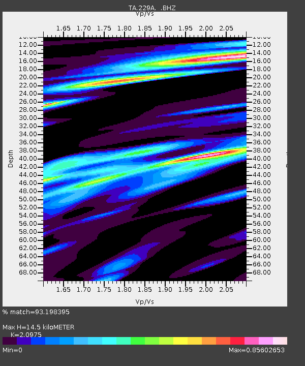
| Estimated Moho Depth: |
14.5 km |
| Estimated Crust Vp/Vs: |
2.10 |
| Assumed Crust Vp: |
6.38 km/s |
| Estimated Crust Vs: |
3.042 km/s |
| Estimated Crust Poisson's Ratio: |
0.35 |
|
| Radial Match: |
93.198395 % |
| Radial Bump: |
400 |
| Transverse Match: |
81.41168 % |
| Transverse Bump: |
400 |
| SOD ConfigId: |
2658 |
| Insert Time: |
2010-03-05 23:25:45.995 +0000 |
| GWidth: |
2.5 |
| Max Bumps: |
400 |
| Tol: |
0.001 |
|
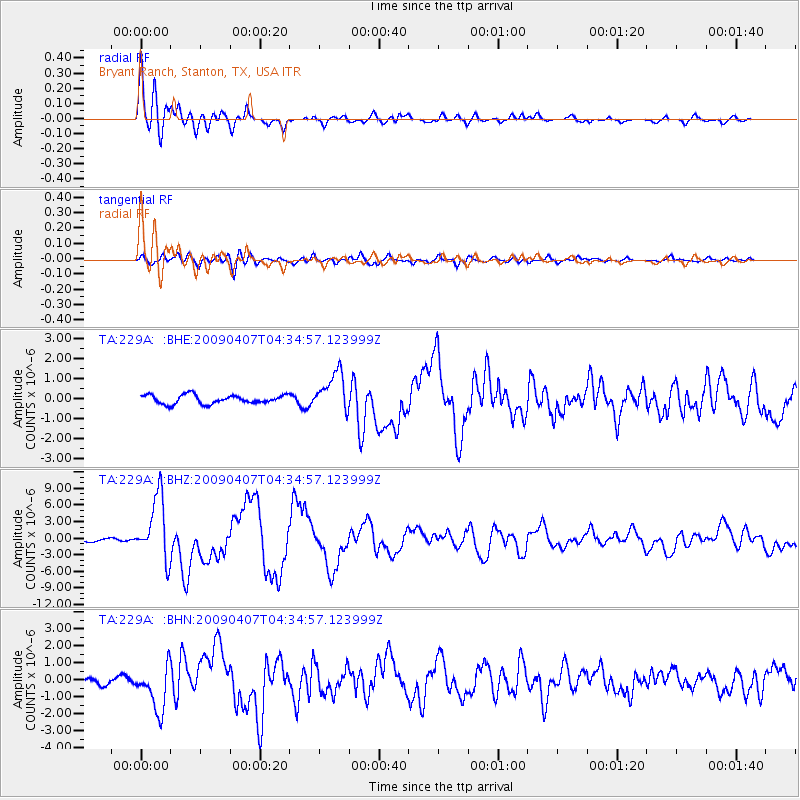
Signal To Noise
| Channel | StoN | STA | LTA |
| TA:229A: :BHZ:20090407T04:34:57.123999Z | 19.581429 | 5.706384E-6 | 2.9141816E-7 |
| TA:229A: :BHN:20090407T04:34:57.123999Z | 7.635656 | 1.3292608E-6 | 1.74086E-7 |
| TA:229A: :BHE:20090407T04:34:57.123999Z | 4.4533367 | 9.790402E-7 | 2.1984418E-7 |
| Arrivals |
| Ps | 2.6 SECOND |
| PpPs | 6.9 SECOND |
| PsPs/PpSs | 9.4 SECOND |


