You are here: Home > Network List > HV - Hawaiian Volcano Observatory Network Stations List
> Station MLOD Mauna Loa, Hawaii Digital > Earthquake Result Viewer
MLOD Mauna Loa, Hawaii Digital - Earthquake Result Viewer
| Earthquake location: |
Mindanao, Philippines |
| Earthquake latitude/longitude: |
5.5/125.1 |
| Earthquake time(UTC): |
2017/04/28 (118) 20:23:18 GMT |
| Earthquake Depth: |
10 km |
| Earthquake Magnitude: |
7.2 Mi |
| Earthquake Catalog/Contributor: |
NEIC PDE/pt |
|
| Network: |
HV Hawaiian Volcano Observatory Network |
| Station: |
MLOD Mauna Loa, Hawaii Digital |
| Lat/Lon: |
19.49 N/155.39 W |
| Elevation: |
2044 m |
|
| Distance: |
78.4 deg |
| Az: |
71.302 deg |
| Baz: |
271.732 deg |
| Ray Param: |
0.049691405 |
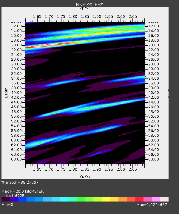
| Estimated Moho Depth: |
20.0 km |
| Estimated Crust Vp/Vs: |
1.67 |
| Assumed Crust Vp: |
5.195 km/s |
| Estimated Crust Vs: |
3.106 km/s |
| Estimated Crust Poisson's Ratio: |
0.22 |
|
| Radial Match: |
88.27607 % |
| Radial Bump: |
400 |
| Transverse Match: |
74.45363 % |
| Transverse Bump: |
400 |
| SOD ConfigId: |
11737051 |
| Insert Time: |
2019-04-27 05:57:52.810 +0000 |
| GWidth: |
2.5 |
| Max Bumps: |
400 |
| Tol: |
0.001 |
|
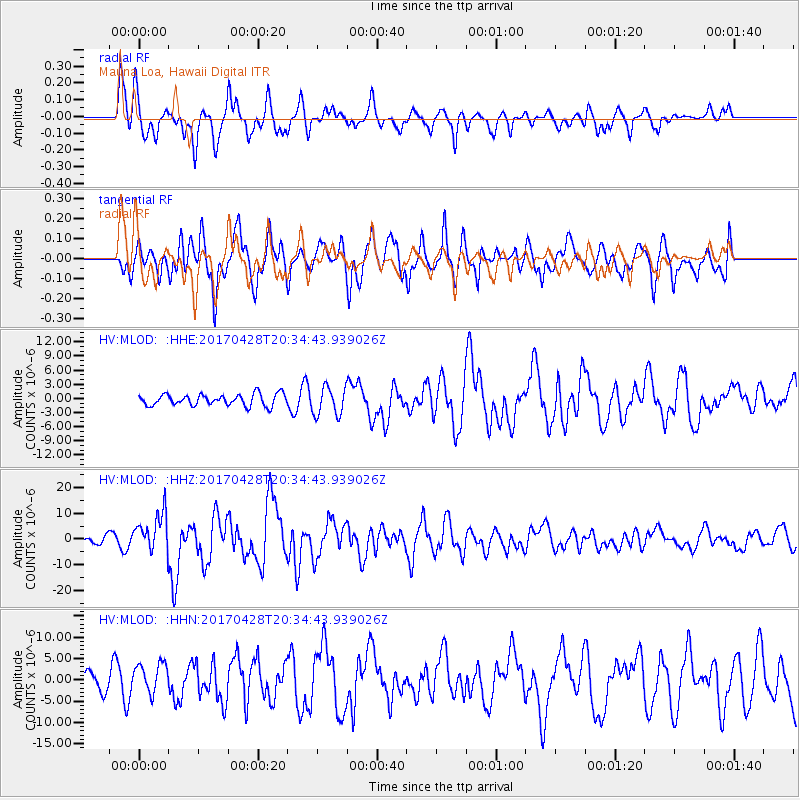
Signal To Noise
| Channel | StoN | STA | LTA |
| HV:MLOD: :HHZ:20170428T20:34:43.939026Z | 5.429567 | 7.722764E-6 | 1.4223536E-6 |
| HV:MLOD: :HHN:20170428T20:34:43.939026Z | 1.2449183 | 3.53702E-6 | 2.8411664E-6 |
| HV:MLOD: :HHE:20170428T20:34:43.939026Z | 1.9568217 | 3.1440545E-6 | 1.6067149E-6 |
| Arrivals |
| Ps | 2.6 SECOND |
| PpPs | 10 SECOND |
| PsPs/PpSs | 13 SECOND |


