You are here: Home > Network List > TA - USArray Transportable Network (new EarthScope stations) Stations List
> Station 229A Bryant Ranch, Stanton, TX, USA > Earthquake Result Viewer
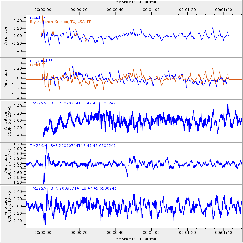
229A Bryant Ranch, Stanton, TX, USA - Earthquake Result Viewer
*The percent match for this event was below the threshold and hence no stack was calculated.
| Earthquake location: |
Chile-Bolivia Border Region |
| Earthquake latitude/longitude: |
-21.8/-67.1 |
| Earthquake time(UTC): |
2009/07/14 (195) 18:38:08 GMT |
| Earthquake Depth: |
176 km |
| Earthquake Magnitude: |
5.7 MW, 5.4 MB, 5.7 MW |
| Earthquake Catalog/Contributor: |
WHDF/NEIC |
|
| Network: |
TA USArray Transportable Network (new EarthScope stations) |
| Station: |
229A Bryant Ranch, Stanton, TX, USA |
| Lat/Lon: |
31.97 N/101.81 W |
| Elevation: |
804 m |
|
| Distance: |
63.0 deg |
| Az: |
327.078 deg |
| Baz: |
143.546 deg |
| Ray Param: |
$rayparam |
*The percent match for this event was below the threshold and hence was not used in the summary stack. |
|
| Radial Match: |
63.130367 % |
| Radial Bump: |
400 |
| Transverse Match: |
47.15048 % |
| Transverse Bump: |
400 |
| SOD ConfigId: |
2648 |
| Insert Time: |
2010-03-05 23:26:20.164 +0000 |
| GWidth: |
2.5 |
| Max Bumps: |
400 |
| Tol: |
0.001 |
|
Signal To Noise
| Channel | StoN | STA | LTA |
| TA:229A: :BHZ:20090714T18:47:45.650024Z | 5.9870744 | 5.571329E-7 | 9.305595E-8 |
| TA:229A: :BHN:20090714T18:47:45.650024Z | 2.954939 | 2.2835555E-7 | 7.727928E-8 |
| TA:229A: :BHE:20090714T18:47:45.650024Z | 1.4242505 | 2.251015E-7 | 1.5804909E-7 |
| Arrivals |
| Ps | |
| PpPs | |
| PsPs/PpSs | |


