You are here: Home > Network List > TA - USArray Transportable Network (new EarthScope stations) Stations List
> Station C24K Franklin Bluffs, AK, USA > Earthquake Result Viewer
C24K Franklin Bluffs, AK, USA - Earthquake Result Viewer
| Earthquake location: |
Mindanao, Philippines |
| Earthquake latitude/longitude: |
5.5/125.1 |
| Earthquake time(UTC): |
2017/04/28 (118) 20:23:18 GMT |
| Earthquake Depth: |
10 km |
| Earthquake Magnitude: |
7.2 Mi |
| Earthquake Catalog/Contributor: |
NEIC PDE/pt |
|
| Network: |
TA USArray Transportable Network (new EarthScope stations) |
| Station: |
C24K Franklin Bluffs, AK, USA |
| Lat/Lon: |
69.72 N/148.70 W |
| Elevation: |
115 m |
|
| Distance: |
83.6 deg |
| Az: |
20.493 deg |
| Baz: |
268.38 deg |
| Ray Param: |
0.046079446 |
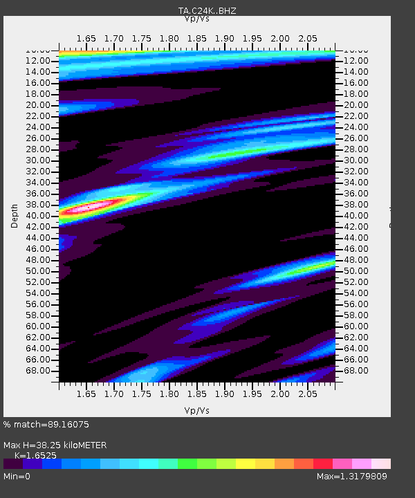
| Estimated Moho Depth: |
38.25 km |
| Estimated Crust Vp/Vs: |
1.65 |
| Assumed Crust Vp: |
6.316 km/s |
| Estimated Crust Vs: |
3.822 km/s |
| Estimated Crust Poisson's Ratio: |
0.21 |
|
| Radial Match: |
89.16075 % |
| Radial Bump: |
400 |
| Transverse Match: |
86.68336 % |
| Transverse Bump: |
400 |
| SOD ConfigId: |
11737051 |
| Insert Time: |
2019-04-27 05:59:32.534 +0000 |
| GWidth: |
2.5 |
| Max Bumps: |
400 |
| Tol: |
0.001 |
|

Signal To Noise
| Channel | StoN | STA | LTA |
| TA:C24K: :BHZ:20170428T20:35:11.650024Z | 107.67651 | 1.1085888E-5 | 1.0295549E-7 |
| TA:C24K: :BHN:20170428T20:35:11.650024Z | 8.947102 | 8.231671E-7 | 9.200377E-8 |
| TA:C24K: :BHE:20170428T20:35:11.650024Z | 21.170456 | 2.63844E-6 | 1.246284E-7 |
| Arrivals |
| Ps | 4.1 SECOND |
| PpPs | 16 SECOND |
| PsPs/PpSs | 20 SECOND |


