You are here: Home > Network List > TA - USArray Transportable Network (new EarthScope stations) Stations List
> Station D25K Kavik River, AK, USA > Earthquake Result Viewer
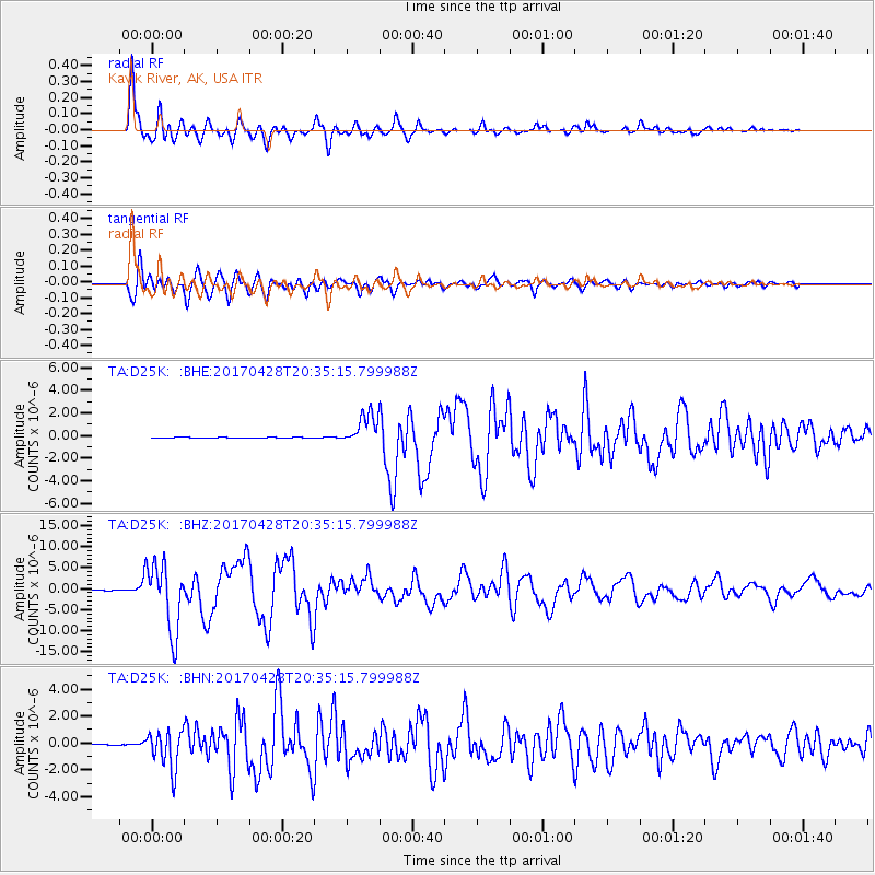
D25K Kavik River, AK, USA - Earthquake Result Viewer
*The percent match for this event was below the threshold and hence no stack was calculated.
| Earthquake location: |
Mindanao, Philippines |
| Earthquake latitude/longitude: |
5.5/125.1 |
| Earthquake time(UTC): |
2017/04/28 (118) 20:23:18 GMT |
| Earthquake Depth: |
10 km |
| Earthquake Magnitude: |
7.2 Mi |
| Earthquake Catalog/Contributor: |
NEIC PDE/pt |
|
| Network: |
TA USArray Transportable Network (new EarthScope stations) |
| Station: |
D25K Kavik River, AK, USA |
| Lat/Lon: |
69.32 N/146.38 W |
| Elevation: |
770 m |
|
| Distance: |
84.4 deg |
| Az: |
20.903 deg |
| Baz: |
270.6 deg |
| Ray Param: |
$rayparam |
*The percent match for this event was below the threshold and hence was not used in the summary stack. |
|
| Radial Match: |
94.72019 % |
| Radial Bump: |
400 |
| Transverse Match: |
92.20523 % |
| Transverse Bump: |
400 |
| SOD ConfigId: |
11737051 |
| Insert Time: |
2019-04-27 05:59:37.497 +0000 |
| GWidth: |
2.5 |
| Max Bumps: |
400 |
| Tol: |
0.001 |
|
Signal To Noise
| Channel | StoN | STA | LTA |
| TA:D25K: :BHZ:20170428T20:35:15.799988Z | 128.36186 | 8.063289E-6 | 6.281686E-8 |
| TA:D25K: :BHN:20170428T20:35:15.799988Z | 34.21047 | 1.4177025E-6 | 4.1440607E-8 |
| TA:D25K: :BHE:20170428T20:35:15.799988Z | 79.118935 | 3.008249E-6 | 3.802186E-8 |
| Arrivals |
| Ps | |
| PpPs | |
| PsPs/PpSs | |


