You are here: Home > Network List > TA - USArray Transportable Network (new EarthScope stations) Stations List
> Station 228A UT Block 9, Goldsmith, TX, USA > Earthquake Result Viewer
228A UT Block 9, Goldsmith, TX, USA - Earthquake Result Viewer
| Earthquake location: |
Near S. Coast Of Honshu, Japan |
| Earthquake latitude/longitude: |
33.2/137.9 |
| Earthquake time(UTC): |
2009/08/09 (221) 10:55:55 GMT |
| Earthquake Depth: |
297 km |
| Earthquake Magnitude: |
6.5 MB, 7.1 MW, 7.1 MW |
| Earthquake Catalog/Contributor: |
WHDF/NEIC |
|
| Network: |
TA USArray Transportable Network (new EarthScope stations) |
| Station: |
228A UT Block 9, Goldsmith, TX, USA |
| Lat/Lon: |
32.12 N/102.59 W |
| Elevation: |
954 m |
|
| Distance: |
93.6 deg |
| Az: |
47.749 deg |
| Baz: |
312.974 deg |
| Ray Param: |
0.04102653 |
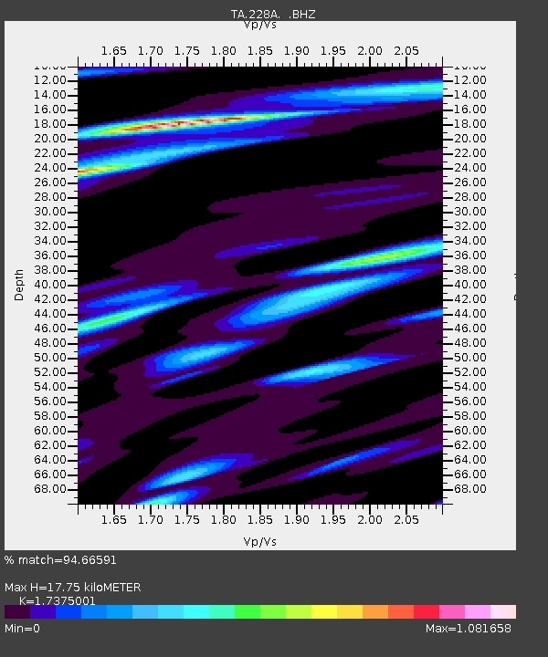
| Estimated Moho Depth: |
17.75 km |
| Estimated Crust Vp/Vs: |
1.74 |
| Assumed Crust Vp: |
6.129 km/s |
| Estimated Crust Vs: |
3.527 km/s |
| Estimated Crust Poisson's Ratio: |
0.25 |
|
| Radial Match: |
94.66591 % |
| Radial Bump: |
400 |
| Transverse Match: |
84.1475 % |
| Transverse Bump: |
400 |
| SOD ConfigId: |
2622 |
| Insert Time: |
2010-03-05 23:26:28.238 +0000 |
| GWidth: |
2.5 |
| Max Bumps: |
400 |
| Tol: |
0.001 |
|

Signal To Noise
| Channel | StoN | STA | LTA |
| TA:228A: :BHZ:20090809T11:08:06.700027Z | 36.62085 | 4.267368E-6 | 1.1652837E-7 |
| TA:228A: :BHN:20090809T11:08:06.700027Z | 13.355008 | 1.0421601E-6 | 7.803515E-8 |
| TA:228A: :BHE:20090809T11:08:06.700027Z | 18.772093 | 1.0627966E-6 | 5.661578E-8 |
| Arrivals |
| Ps | 2.2 SECOND |
| PpPs | 7.8 SECOND |
| PsPs/PpSs | 10.0 SECOND |


