You are here: Home > Network List > US - United States National Seismic Network Stations List
> Station AMTX Amarillo, Texas, USA > Earthquake Result Viewer
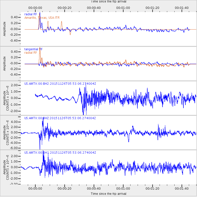
AMTX Amarillo, Texas, USA - Earthquake Result Viewer
*The percent match for this event was below the threshold and hence no stack was calculated.
| Earthquake location: |
Peru-Brazil Border Region |
| Earthquake latitude/longitude: |
-9.2/-71.3 |
| Earthquake time(UTC): |
2015/11/26 (330) 05:45:18 GMT |
| Earthquake Depth: |
604 km |
| Earthquake Magnitude: |
6.4 MWP |
| Earthquake Catalog/Contributor: |
NEIC PDE/NEIC COMCAT |
|
| Network: |
US United States National Seismic Network |
| Station: |
AMTX Amarillo, Texas, USA |
| Lat/Lon: |
34.53 N/101.41 W |
| Elevation: |
1010 m |
|
| Distance: |
52.1 deg |
| Az: |
328.286 deg |
| Baz: |
141.054 deg |
| Ray Param: |
$rayparam |
*The percent match for this event was below the threshold and hence was not used in the summary stack. |
|
| Radial Match: |
74.83003 % |
| Radial Bump: |
389 |
| Transverse Match: |
48.442978 % |
| Transverse Bump: |
400 |
| SOD ConfigId: |
1259291 |
| Insert Time: |
2015-12-10 06:06:06.544 +0000 |
| GWidth: |
2.5 |
| Max Bumps: |
400 |
| Tol: |
0.001 |
|
Signal To Noise
| Channel | StoN | STA | LTA |
| US:AMTX:00:BHZ:20151126T05:53:06.274004Z | 9.722788 | 1.5785695E-6 | 1.6235771E-7 |
| US:AMTX:00:BH1:20151126T05:53:06.274004Z | 2.619057 | 4.0923732E-7 | 1.562537E-7 |
| US:AMTX:00:BH2:20151126T05:53:06.274004Z | 2.425 | 5.918812E-7 | 2.4407473E-7 |
| Arrivals |
| Ps | |
| PpPs | |
| PsPs/PpSs | |


