You are here: Home > Network List > TA - USArray Transportable Network (new EarthScope stations) Stations List
> Station 228A UT Block 9, Goldsmith, TX, USA > Earthquake Result Viewer
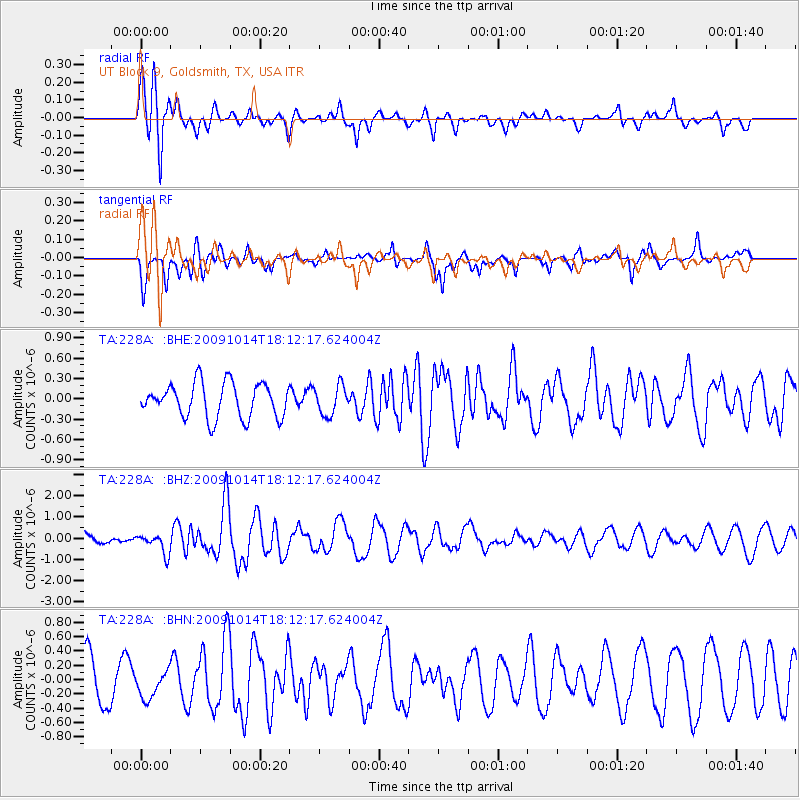
228A UT Block 9, Goldsmith, TX, USA - Earthquake Result Viewer

| Earthquake location: |
Samoa Islands Region |
| Earthquake latitude/longitude: |
-14.9/-174.8 |
| Earthquake time(UTC): |
2009/10/14 (287) 18:00:21 GMT |
| Earthquake Depth: |
10 km |
| Earthquake Magnitude: |
5.7 MB, 6.0 MS, 6.3 MW, 6.2 MW |
| Earthquake Catalog/Contributor: |
WHDF/NEIC |
|
| Network: |
TA USArray Transportable Network (new EarthScope stations) |
| Station: |
228A UT Block 9, Goldsmith, TX, USA |
| Lat/Lon: |
32.12 N/102.59 W |
| Elevation: |
954 m |
|
| Distance: |
83.4 deg |
| Az: |
54.437 deg |
| Baz: |
247.941 deg |
| Ray Param: |
0.046220694 |
| Estimated Moho Depth: |
11.5 km |
| Estimated Crust Vp/Vs: |
2.10 |
| Assumed Crust Vp: |
6.129 km/s |
| Estimated Crust Vs: |
2.922 km/s |
| Estimated Crust Poisson's Ratio: |
0.35 |
|
| Radial Match: |
82.19389 % |
| Radial Bump: |
400 |
| Transverse Match: |
68.1555 % |
| Transverse Bump: |
400 |
| SOD ConfigId: |
2622 |
| Insert Time: |
2010-03-05 23:26:41.137 +0000 |
| GWidth: |
2.5 |
| Max Bumps: |
400 |
| Tol: |
0.001 |
|
Signal To Noise
| Channel | StoN | STA | LTA |
| TA:228A: :BHZ:20091014T18:12:17.624004Z | 1.8560954 | 4.567932E-7 | 2.4610438E-7 |
| TA:228A: :BHN:20091014T18:12:17.624004Z | 0.71428657 | 1.874668E-7 | 2.624532E-7 |
| TA:228A: :BHE:20091014T18:12:17.624004Z | 0.8544247 | 2.1623396E-7 | 2.5307548E-7 |
| Arrivals |
| Ps | 2.1 SECOND |
| PpPs | 5.7 SECOND |
| PsPs/PpSs | 7.8 SECOND |


