You are here: Home > Network List > ZE15 - Southern Alaska Lithosphere and Mantle Observation Network Stations List
> Station MPEN Moose Pens 2, Alaska > Earthquake Result Viewer
MPEN Moose Pens 2, Alaska - Earthquake Result Viewer
| Earthquake location: |
Mindanao, Philippines |
| Earthquake latitude/longitude: |
5.5/125.1 |
| Earthquake time(UTC): |
2017/04/28 (118) 20:23:18 GMT |
| Earthquake Depth: |
10 km |
| Earthquake Magnitude: |
7.2 Mi |
| Earthquake Catalog/Contributor: |
NEIC PDE/pt |
|
| Network: |
ZE Southern Alaska Lithosphere and Mantle Observation Network |
| Station: |
MPEN Moose Pens 2, Alaska |
| Lat/Lon: |
60.74 N/150.48 W |
| Elevation: |
124 m |
|
| Distance: |
82.5 deg |
| Az: |
29.553 deg |
| Baz: |
267.856 deg |
| Ray Param: |
0.046815425 |
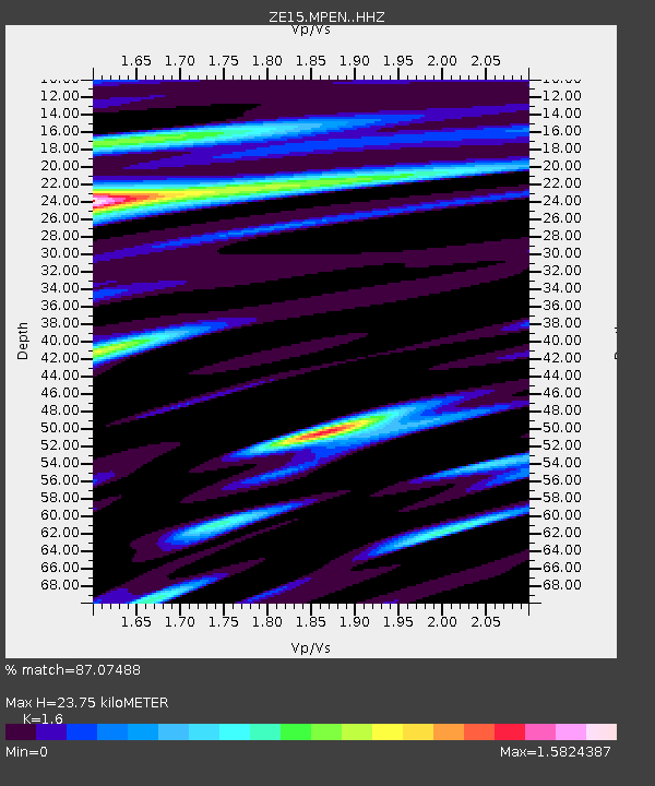
| Estimated Moho Depth: |
23.75 km |
| Estimated Crust Vp/Vs: |
1.60 |
| Assumed Crust Vp: |
6.302 km/s |
| Estimated Crust Vs: |
3.938 km/s |
| Estimated Crust Poisson's Ratio: |
0.18 |
|
| Radial Match: |
87.07488 % |
| Radial Bump: |
400 |
| Transverse Match: |
66.120895 % |
| Transverse Bump: |
400 |
| SOD ConfigId: |
11737051 |
| Insert Time: |
2019-04-27 06:01:31.111 +0000 |
| GWidth: |
2.5 |
| Max Bumps: |
400 |
| Tol: |
0.001 |
|

Signal To Noise
| Channel | StoN | STA | LTA |
| ZE:MPEN: :HHZ:20170428T20:35:06.23999Z | 42.267593 | 1.119883E-5 | 2.6495076E-7 |
| ZE:MPEN: :HHN:20170428T20:35:06.23999Z | 1.4493227 | 9.113167E-7 | 6.28788E-7 |
| ZE:MPEN: :HHE:20170428T20:35:06.23999Z | 13.625907 | 5.275343E-6 | 3.8715538E-7 |
| Arrivals |
| Ps | 2.3 SECOND |
| PpPs | 9.5 SECOND |
| PsPs/PpSs | 12 SECOND |


