You are here: Home > Network List > TA - USArray Transportable Network (new EarthScope stations) Stations List
> Station 228A UT Block 9, Goldsmith, TX, USA > Earthquake Result Viewer
228A UT Block 9, Goldsmith, TX, USA - Earthquake Result Viewer
| Earthquake location: |
Kermadec Islands Region |
| Earthquake latitude/longitude: |
-31.5/-178.8 |
| Earthquake time(UTC): |
2009/05/16 (136) 00:53:52 GMT |
| Earthquake Depth: |
55 km |
| Earthquake Magnitude: |
6.1 MB, 6.5 MW, 6.3 MW |
| Earthquake Catalog/Contributor: |
WHDF/NEIC |
|
| Network: |
TA USArray Transportable Network (new EarthScope stations) |
| Station: |
228A UT Block 9, Goldsmith, TX, USA |
| Lat/Lon: |
32.12 N/102.59 W |
| Elevation: |
954 m |
|
| Distance: |
95.9 deg |
| Az: |
55.937 deg |
| Baz: |
236.487 deg |
| Ray Param: |
0.04063356 |
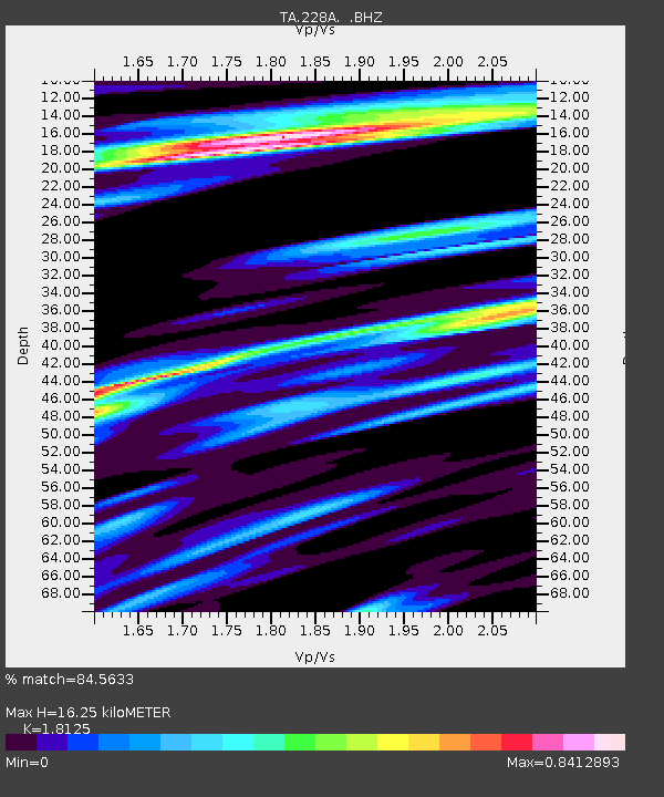
| Estimated Moho Depth: |
16.25 km |
| Estimated Crust Vp/Vs: |
1.81 |
| Assumed Crust Vp: |
6.129 km/s |
| Estimated Crust Vs: |
3.381 km/s |
| Estimated Crust Poisson's Ratio: |
0.28 |
|
| Radial Match: |
84.5633 % |
| Radial Bump: |
400 |
| Transverse Match: |
65.52608 % |
| Transverse Bump: |
400 |
| SOD ConfigId: |
2760 |
| Insert Time: |
2010-03-05 23:27:01.220 +0000 |
| GWidth: |
2.5 |
| Max Bumps: |
400 |
| Tol: |
0.001 |
|

Signal To Noise
| Channel | StoN | STA | LTA |
| TA:228A: :BHZ:20090516T01:06:42.023997Z | 7.352381 | 6.600291E-7 | 8.97708E-8 |
| TA:228A: :BHN:20090516T01:06:42.023997Z | 0.941693 | 1.4271369E-7 | 1.5155013E-7 |
| TA:228A: :BHE:20090516T01:06:42.023997Z | 3.553999 | 2.497887E-7 | 7.0283846E-8 |
| Arrivals |
| Ps | 2.2 SECOND |
| PpPs | 7.3 SECOND |
| PsPs/PpSs | 9.5 SECOND |


