You are here: Home > Network List > US - United States National Seismic Network Stations List
> Station ELK Elko, Nevada, USA > Earthquake Result Viewer
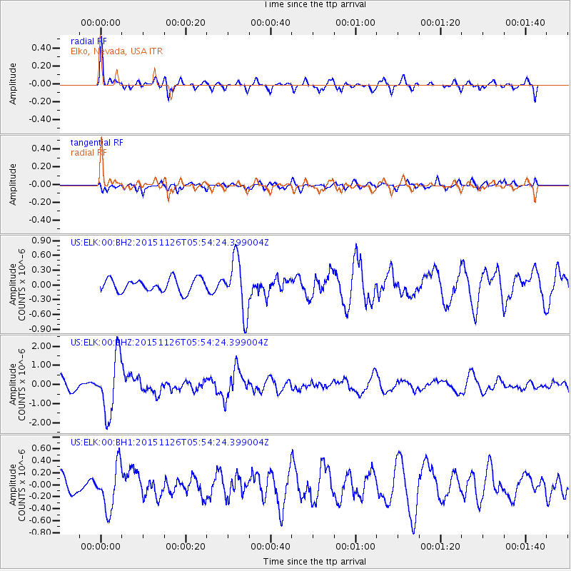
ELK Elko, Nevada, USA - Earthquake Result Viewer
*The percent match for this event was below the threshold and hence no stack was calculated.
| Earthquake location: |
Peru-Brazil Border Region |
| Earthquake latitude/longitude: |
-9.2/-71.3 |
| Earthquake time(UTC): |
2015/11/26 (330) 05:45:18 GMT |
| Earthquake Depth: |
604 km |
| Earthquake Magnitude: |
6.4 MWP |
| Earthquake Catalog/Contributor: |
NEIC PDE/NEIC COMCAT |
|
| Network: |
US United States National Seismic Network |
| Station: |
ELK Elko, Nevada, USA |
| Lat/Lon: |
40.74 N/115.24 W |
| Elevation: |
2210 m |
|
| Distance: |
64.1 deg |
| Az: |
324.111 deg |
| Baz: |
130.386 deg |
| Ray Param: |
$rayparam |
*The percent match for this event was below the threshold and hence was not used in the summary stack. |
|
| Radial Match: |
69.72455 % |
| Radial Bump: |
327 |
| Transverse Match: |
50.799736 % |
| Transverse Bump: |
400 |
| SOD ConfigId: |
1259291 |
| Insert Time: |
2015-12-10 06:06:52.121 +0000 |
| GWidth: |
2.5 |
| Max Bumps: |
400 |
| Tol: |
0.001 |
|
Signal To Noise
| Channel | StoN | STA | LTA |
| US:ELK:00:BHZ:20151126T05:54:24.399004Z | 5.487835 | 1.545744E-6 | 2.8166735E-7 |
| US:ELK:00:BH1:20151126T05:54:24.399004Z | 2.6348906 | 3.7895046E-7 | 1.4382019E-7 |
| US:ELK:00:BH2:20151126T05:54:24.399004Z | 4.215242 | 5.5961596E-7 | 1.327601E-7 |
| Arrivals |
| Ps | |
| PpPs | |
| PsPs/PpSs | |


