You are here: Home > Network List > AK - Alaska Regional Network Stations List
> Station CUT Chulitna, AK, USA > Earthquake Result Viewer
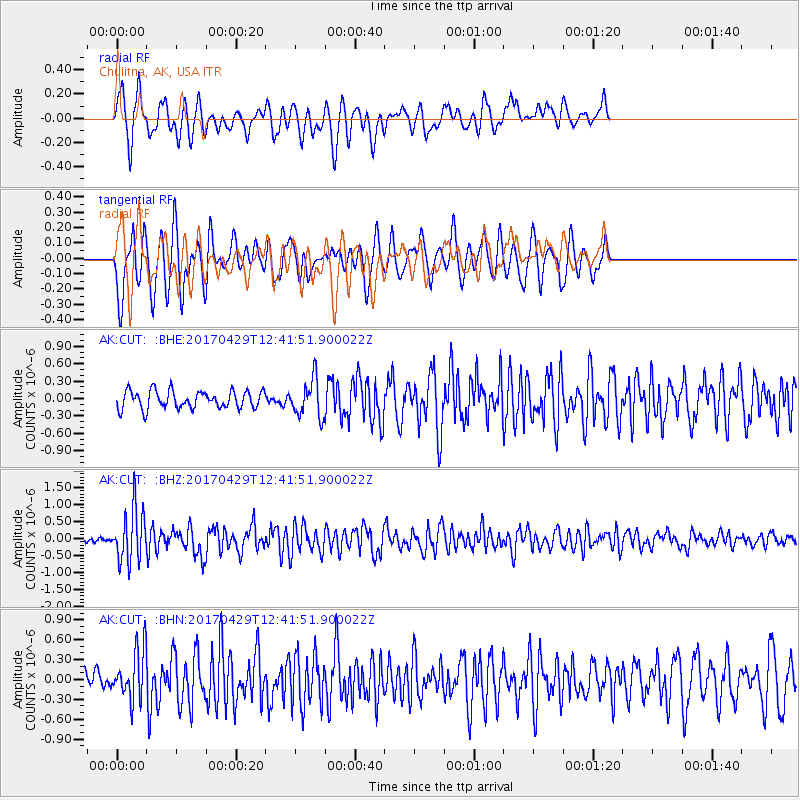
CUT Chulitna, AK, USA - Earthquake Result Viewer
*The percent match for this event was below the threshold and hence no stack was calculated.
| Earthquake location: |
Kyushu, Japan |
| Earthquake latitude/longitude: |
30.8/131.4 |
| Earthquake time(UTC): |
2017/04/29 (119) 12:32:32 GMT |
| Earthquake Depth: |
21 km |
| Earthquake Magnitude: |
5.7 Mww |
| Earthquake Catalog/Contributor: |
NEIC PDE/us |
|
| Network: |
AK Alaska Regional Network |
| Station: |
CUT Chulitna, AK, USA |
| Lat/Lon: |
62.41 N/150.26 W |
| Elevation: |
574 m |
|
| Distance: |
57.8 deg |
| Az: |
32.59 deg |
| Baz: |
275.63 deg |
| Ray Param: |
$rayparam |
*The percent match for this event was below the threshold and hence was not used in the summary stack. |
|
| Radial Match: |
59.676846 % |
| Radial Bump: |
400 |
| Transverse Match: |
65.786606 % |
| Transverse Bump: |
400 |
| SOD ConfigId: |
11737051 |
| Insert Time: |
2019-04-27 06:06:16.713 +0000 |
| GWidth: |
2.5 |
| Max Bumps: |
400 |
| Tol: |
0.001 |
|
Signal To Noise
| Channel | StoN | STA | LTA |
| AK:CUT: :BHZ:20170429T12:41:51.900022Z | 5.936331 | 7.8069974E-7 | 1.3151217E-7 |
| AK:CUT: :BHN:20170429T12:41:51.900022Z | 1.6713957 | 3.6989454E-7 | 2.2130878E-7 |
| AK:CUT: :BHE:20170429T12:41:51.900022Z | 2.0634553 | 3.115317E-7 | 1.5097574E-7 |
| Arrivals |
| Ps | |
| PpPs | |
| PsPs/PpSs | |


