You are here: Home > Network List > TA - USArray Transportable Network (new EarthScope stations) Stations List
> Station WHTX Lake Whitney, Meridian, TX, USA > Earthquake Result Viewer
WHTX Lake Whitney, Meridian, TX, USA - Earthquake Result Viewer
| Earthquake location: |
Rat Islands, Aleutian Islands |
| Earthquake latitude/longitude: |
50.4/177.0 |
| Earthquake time(UTC): |
2009/07/06 (187) 14:53:12 GMT |
| Earthquake Depth: |
22 km |
| Earthquake Magnitude: |
6.0 MB, 5.8 MS, 6.1 MW, 6.0 MW |
| Earthquake Catalog/Contributor: |
WHDF/NEIC |
|
| Network: |
TA USArray Transportable Network (new EarthScope stations) |
| Station: |
WHTX Lake Whitney, Meridian, TX, USA |
| Lat/Lon: |
31.99 N/97.46 W |
| Elevation: |
190 m |
|
| Distance: |
63.4 deg |
| Az: |
71.315 deg |
| Baz: |
314.526 deg |
| Ray Param: |
0.05956345 |
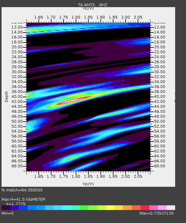
| Estimated Moho Depth: |
41.5 km |
| Estimated Crust Vp/Vs: |
1.78 |
| Assumed Crust Vp: |
6.347 km/s |
| Estimated Crust Vs: |
3.571 km/s |
| Estimated Crust Poisson's Ratio: |
0.27 |
|
| Radial Match: |
94.358055 % |
| Radial Bump: |
384 |
| Transverse Match: |
84.08309 % |
| Transverse Bump: |
400 |
| SOD ConfigId: |
2648 |
| Insert Time: |
2010-03-05 23:27:54.600 +0000 |
| GWidth: |
2.5 |
| Max Bumps: |
400 |
| Tol: |
0.001 |
|

Signal To Noise
| Channel | StoN | STA | LTA |
| TA:WHTX: :BHZ:20090706T15:03:09.023997Z | 25.320848 | 2.4033868E-6 | 9.491731E-8 |
| TA:WHTX: :BHN:20090706T15:03:09.023997Z | 9.50504 | 9.872375E-7 | 1.0386463E-7 |
| TA:WHTX: :BHE:20090706T15:03:09.023997Z | 9.559417 | 8.781441E-7 | 9.186168E-8 |
| Arrivals |
| Ps | 5.3 SECOND |
| PpPs | 17 SECOND |
| PsPs/PpSs | 23 SECOND |


