You are here: Home > Network List > US - United States National Seismic Network Stations List
> Station MSO Missoula, Montana, USA > Earthquake Result Viewer
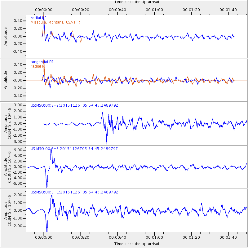
MSO Missoula, Montana, USA - Earthquake Result Viewer
*The percent match for this event was below the threshold and hence no stack was calculated.
| Earthquake location: |
Peru-Brazil Border Region |
| Earthquake latitude/longitude: |
-9.2/-71.3 |
| Earthquake time(UTC): |
2015/11/26 (330) 05:45:18 GMT |
| Earthquake Depth: |
604 km |
| Earthquake Magnitude: |
6.4 MWP |
| Earthquake Catalog/Contributor: |
NEIC PDE/NEIC COMCAT |
|
| Network: |
US United States National Seismic Network |
| Station: |
MSO Missoula, Montana, USA |
| Lat/Lon: |
46.83 N/113.94 W |
| Elevation: |
1264 m |
|
| Distance: |
67.5 deg |
| Az: |
329.756 deg |
| Baz: |
133.597 deg |
| Ray Param: |
$rayparam |
*The percent match for this event was below the threshold and hence was not used in the summary stack. |
|
| Radial Match: |
78.07673 % |
| Radial Bump: |
400 |
| Transverse Match: |
77.42537 % |
| Transverse Bump: |
400 |
| SOD ConfigId: |
1259291 |
| Insert Time: |
2015-12-10 06:08:07.471 +0000 |
| GWidth: |
2.5 |
| Max Bumps: |
400 |
| Tol: |
0.001 |
|
Signal To Noise
| Channel | StoN | STA | LTA |
| US:MSO:00:BHZ:20151126T05:54:45.248979Z | 22.50456 | 3.4698337E-6 | 1.5418358E-7 |
| US:MSO:00:BH1:20151126T05:54:45.248979Z | 5.5117345 | 1.2195949E-6 | 2.2127243E-7 |
| US:MSO:00:BH2:20151126T05:54:45.248979Z | 9.341532 | 1.1308338E-6 | 1.2105444E-7 |
| Arrivals |
| Ps | |
| PpPs | |
| PsPs/PpSs | |


