You are here: Home > Network List > TA - USArray Transportable Network (new EarthScope stations) Stations List
> Station F25K Christian River, AK, USA > Earthquake Result Viewer
F25K Christian River, AK, USA - Earthquake Result Viewer
| Earthquake location: |
Kyushu, Japan |
| Earthquake latitude/longitude: |
30.8/131.4 |
| Earthquake time(UTC): |
2017/04/29 (119) 12:32:32 GMT |
| Earthquake Depth: |
21 km |
| Earthquake Magnitude: |
5.7 Mww |
| Earthquake Catalog/Contributor: |
NEIC PDE/us |
|
| Network: |
TA USArray Transportable Network (new EarthScope stations) |
| Station: |
F25K Christian River, AK, USA |
| Lat/Lon: |
67.59 N/145.64 W |
| Elevation: |
864 m |
|
| Distance: |
59.2 deg |
| Az: |
26.277 deg |
| Baz: |
276.52 deg |
| Ray Param: |
0.062289435 |
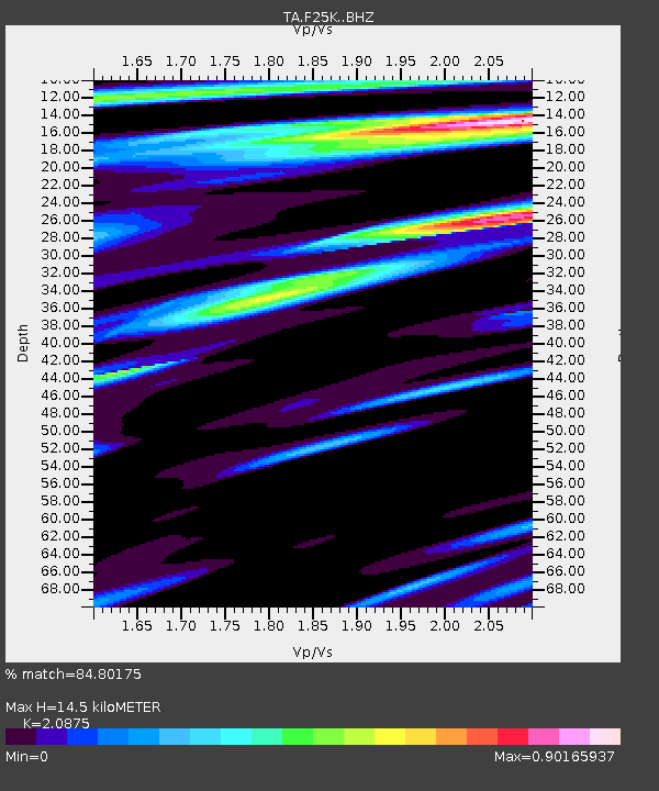
| Estimated Moho Depth: |
14.5 km |
| Estimated Crust Vp/Vs: |
2.09 |
| Assumed Crust Vp: |
6.522 km/s |
| Estimated Crust Vs: |
3.124 km/s |
| Estimated Crust Poisson's Ratio: |
0.35 |
|
| Radial Match: |
84.80175 % |
| Radial Bump: |
400 |
| Transverse Match: |
65.644455 % |
| Transverse Bump: |
400 |
| SOD ConfigId: |
11737051 |
| Insert Time: |
2019-04-27 06:13:55.126 +0000 |
| GWidth: |
2.5 |
| Max Bumps: |
400 |
| Tol: |
0.001 |
|

Signal To Noise
| Channel | StoN | STA | LTA |
| TA:F25K: :BHZ:20170429T12:42:01.650022Z | 4.3039637 | 4.045536E-7 | 9.399559E-8 |
| TA:F25K: :BHN:20170429T12:42:01.650022Z | 1.0737617 | 6.930955E-8 | 6.454835E-8 |
| TA:F25K: :BHE:20170429T12:42:01.650022Z | 2.152665 | 1.6076699E-7 | 7.4682774E-8 |
| Arrivals |
| Ps | 2.5 SECOND |
| PpPs | 6.6 SECOND |
| PsPs/PpSs | 9.1 SECOND |


