You are here: Home > Network List > TA - USArray Transportable Network (new EarthScope stations) Stations List
> Station M31M Drury Creek, Yukon, CA > Earthquake Result Viewer
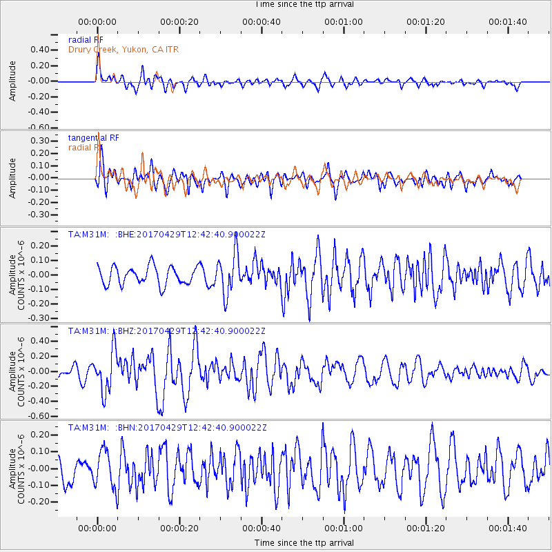
M31M Drury Creek, Yukon, CA - Earthquake Result Viewer
*The percent match for this event was below the threshold and hence no stack was calculated.
| Earthquake location: |
Kyushu, Japan |
| Earthquake latitude/longitude: |
30.8/131.4 |
| Earthquake time(UTC): |
2017/04/29 (119) 12:32:32 GMT |
| Earthquake Depth: |
21 km |
| Earthquake Magnitude: |
5.7 Mww |
| Earthquake Catalog/Contributor: |
NEIC PDE/us |
|
| Network: |
TA USArray Transportable Network (new EarthScope stations) |
| Station: |
M31M Drury Creek, Yukon, CA |
| Lat/Lon: |
62.20 N/134.39 W |
| Elevation: |
639 m |
|
| Distance: |
65.1 deg |
| Az: |
31.025 deg |
| Baz: |
288.934 deg |
| Ray Param: |
$rayparam |
*The percent match for this event was below the threshold and hence was not used in the summary stack. |
|
| Radial Match: |
67.082794 % |
| Radial Bump: |
400 |
| Transverse Match: |
68.01259 % |
| Transverse Bump: |
400 |
| SOD ConfigId: |
11737051 |
| Insert Time: |
2019-04-27 06:14:28.137 +0000 |
| GWidth: |
2.5 |
| Max Bumps: |
400 |
| Tol: |
0.001 |
|
Signal To Noise
| Channel | StoN | STA | LTA |
| TA:M31M: :BHZ:20170429T12:42:40.900022Z | 3.913089 | 2.8119987E-7 | 7.186136E-8 |
| TA:M31M: :BHN:20170429T12:42:40.900022Z | 2.2893531 | 1.15511654E-7 | 5.0456027E-8 |
| TA:M31M: :BHE:20170429T12:42:40.900022Z | 2.354014 | 1.4469626E-7 | 6.146788E-8 |
| Arrivals |
| Ps | |
| PpPs | |
| PsPs/PpSs | |


