You are here: Home > Network List > UW - Pacific Northwest Regional Seismic Network Stations List
> Station LCCR Mulino, OR, USA > Earthquake Result Viewer
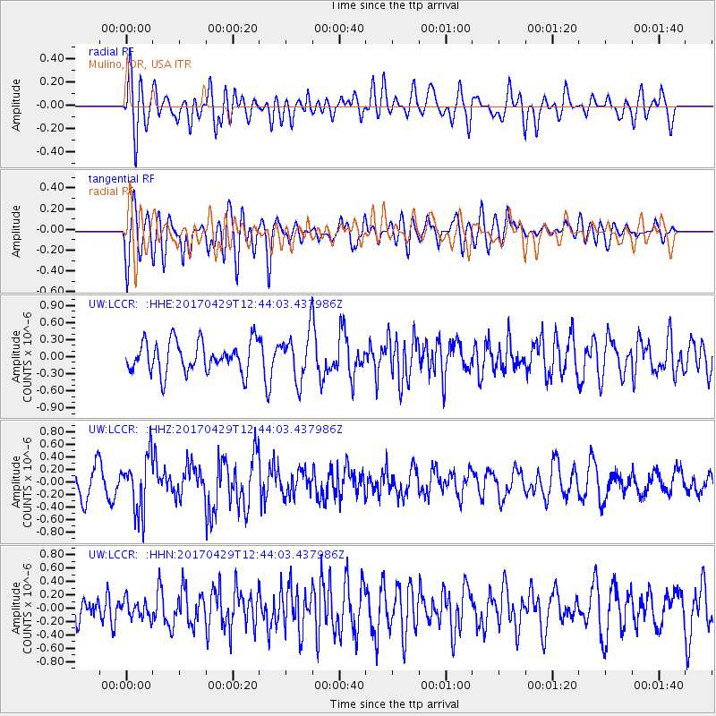
LCCR Mulino, OR, USA - Earthquake Result Viewer
*The percent match for this event was below the threshold and hence no stack was calculated.
| Earthquake location: |
Kyushu, Japan |
| Earthquake latitude/longitude: |
30.8/131.4 |
| Earthquake time(UTC): |
2017/04/29 (119) 12:32:32 GMT |
| Earthquake Depth: |
21 km |
| Earthquake Magnitude: |
5.7 Mww |
| Earthquake Catalog/Contributor: |
NEIC PDE/us |
|
| Network: |
UW Pacific Northwest Regional Seismic Network |
| Station: |
LCCR Mulino, OR, USA |
| Lat/Lon: |
45.21 N/122.48 W |
| Elevation: |
273 m |
|
| Distance: |
78.9 deg |
| Az: |
43.797 deg |
| Baz: |
302.617 deg |
| Ray Param: |
$rayparam |
*The percent match for this event was below the threshold and hence was not used in the summary stack. |
|
| Radial Match: |
48.281918 % |
| Radial Bump: |
400 |
| Transverse Match: |
60.67613 % |
| Transverse Bump: |
400 |
| SOD ConfigId: |
11737051 |
| Insert Time: |
2019-04-27 06:15:37.009 +0000 |
| GWidth: |
2.5 |
| Max Bumps: |
400 |
| Tol: |
0.001 |
|
Signal To Noise
| Channel | StoN | STA | LTA |
| UW:LCCR: :HHZ:20170429T12:44:03.437986Z | 2.671548 | 4.4862497E-7 | 1.6792697E-7 |
| UW:LCCR: :HHN:20170429T12:44:03.437986Z | 0.6360605 | 1.380526E-7 | 2.170432E-7 |
| UW:LCCR: :HHE:20170429T12:44:03.437986Z | 1.4166242 | 3.8253154E-7 | 2.7003034E-7 |
| Arrivals |
| Ps | |
| PpPs | |
| PsPs/PpSs | |


