You are here: Home > Network List > UW - Pacific Northwest Regional Seismic Network Stations List
> Station LEBA Lebam, WA, USA > Earthquake Result Viewer
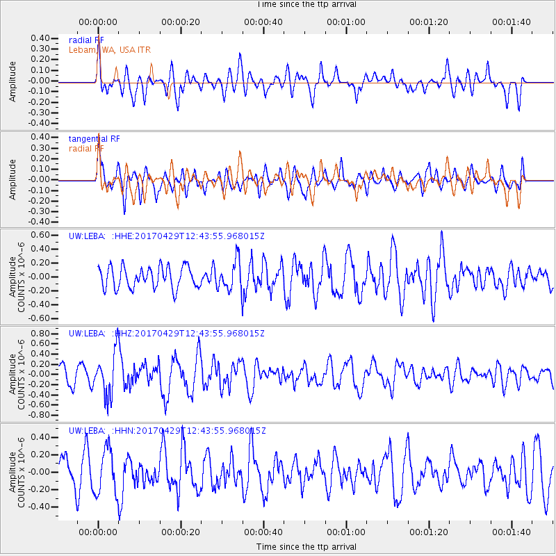
LEBA Lebam, WA, USA - Earthquake Result Viewer
*The percent match for this event was below the threshold and hence no stack was calculated.
| Earthquake location: |
Kyushu, Japan |
| Earthquake latitude/longitude: |
30.8/131.4 |
| Earthquake time(UTC): |
2017/04/29 (119) 12:32:32 GMT |
| Earthquake Depth: |
21 km |
| Earthquake Magnitude: |
5.7 Mww |
| Earthquake Catalog/Contributor: |
NEIC PDE/us |
|
| Network: |
UW Pacific Northwest Regional Seismic Network |
| Station: |
LEBA Lebam, WA, USA |
| Lat/Lon: |
46.55 N/123.56 W |
| Elevation: |
73 m |
|
| Distance: |
77.6 deg |
| Az: |
43.05 deg |
| Baz: |
301.689 deg |
| Ray Param: |
$rayparam |
*The percent match for this event was below the threshold and hence was not used in the summary stack. |
|
| Radial Match: |
57.891716 % |
| Radial Bump: |
400 |
| Transverse Match: |
54.799866 % |
| Transverse Bump: |
400 |
| SOD ConfigId: |
11737051 |
| Insert Time: |
2019-04-27 06:15:37.470 +0000 |
| GWidth: |
2.5 |
| Max Bumps: |
400 |
| Tol: |
0.001 |
|
Signal To Noise
| Channel | StoN | STA | LTA |
| UW:LEBA: :HHZ:20170429T12:43:55.968015Z | 2.7160013 | 4.342466E-7 | 1.5988454E-7 |
| UW:LEBA: :HHN:20170429T12:43:55.968015Z | 1.2763889 | 2.617041E-7 | 2.0503475E-7 |
| UW:LEBA: :HHE:20170429T12:43:55.968015Z | 1.3882284 | 2.1115166E-7 | 1.5210152E-7 |
| Arrivals |
| Ps | |
| PpPs | |
| PsPs/PpSs | |


