You are here: Home > Network List > TA - USArray Transportable Network (new EarthScope stations) Stations List
> Station 430A Baggett Ranch, Ozona, TX, USA > Earthquake Result Viewer
430A Baggett Ranch, Ozona, TX, USA - Earthquake Result Viewer
| Earthquake location: |
Norwegian Sea |
| Earthquake latitude/longitude: |
72.2/0.9 |
| Earthquake time(UTC): |
2009/08/20 (232) 06:35:04 GMT |
| Earthquake Depth: |
6.0 km |
| Earthquake Magnitude: |
5.9 MB, 5.7 MS, 6.0 MW, 6.0 MW |
| Earthquake Catalog/Contributor: |
WHDF/NEIC |
|
| Network: |
TA USArray Transportable Network (new EarthScope stations) |
| Station: |
430A Baggett Ranch, Ozona, TX, USA |
| Lat/Lon: |
30.79 N/101.24 W |
| Elevation: |
768 m |
|
| Distance: |
64.6 deg |
| Az: |
291.385 deg |
| Baz: |
19.438 deg |
| Ray Param: |
0.058820114 |
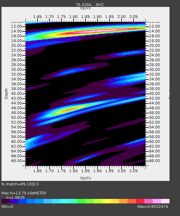
| Estimated Moho Depth: |
13.75 km |
| Estimated Crust Vp/Vs: |
1.89 |
| Assumed Crust Vp: |
6.38 km/s |
| Estimated Crust Vs: |
3.371 km/s |
| Estimated Crust Poisson's Ratio: |
0.31 |
|
| Radial Match: |
95.10013 % |
| Radial Bump: |
399 |
| Transverse Match: |
82.84676 % |
| Transverse Bump: |
400 |
| SOD ConfigId: |
2622 |
| Insert Time: |
2010-03-05 23:28:39.327 +0000 |
| GWidth: |
2.5 |
| Max Bumps: |
400 |
| Tol: |
0.001 |
|
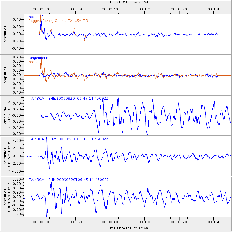
Signal To Noise
| Channel | StoN | STA | LTA |
| TA:430A: :BHZ:20090820T06:45:11.45002Z | 12.916736 | 1.7840108E-6 | 1.3811622E-7 |
| TA:430A: :BHN:20090820T06:45:11.45002Z | 12.106956 | 5.0683457E-7 | 4.186309E-8 |
| TA:430A: :BHE:20090820T06:45:11.45002Z | 3.8194818 | 2.578685E-7 | 6.7513994E-8 |
| Arrivals |
| Ps | 2.0 SECOND |
| PpPs | 6.0 SECOND |
| PsPs/PpSs | 8.0 SECOND |


