You are here: Home > Network List > TA - USArray Transportable Network (new EarthScope stations) Stations List
> Station 430A Baggett Ranch, Ozona, TX, USA > Earthquake Result Viewer
430A Baggett Ranch, Ozona, TX, USA - Earthquake Result Viewer
| Earthquake location: |
Tonga Islands |
| Earthquake latitude/longitude: |
-16.3/-173.5 |
| Earthquake time(UTC): |
2009/10/02 (275) 01:07:39 GMT |
| Earthquake Depth: |
8.0 km |
| Earthquake Magnitude: |
6.1 MB, 6.0 MS, 6.1 MW, 6.1 MW |
| Earthquake Catalog/Contributor: |
WHDF/NEIC |
|
| Network: |
TA USArray Transportable Network (new EarthScope stations) |
| Station: |
430A Baggett Ranch, Ozona, TX, USA |
| Lat/Lon: |
30.79 N/101.24 W |
| Elevation: |
768 m |
|
| Distance: |
83.7 deg |
| Az: |
55.541 deg |
| Baz: |
246.913 deg |
| Ray Param: |
0.046005934 |
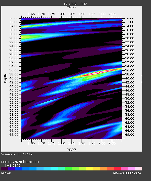
| Estimated Moho Depth: |
36.75 km |
| Estimated Crust Vp/Vs: |
1.99 |
| Assumed Crust Vp: |
6.38 km/s |
| Estimated Crust Vs: |
3.21 km/s |
| Estimated Crust Poisson's Ratio: |
0.33 |
|
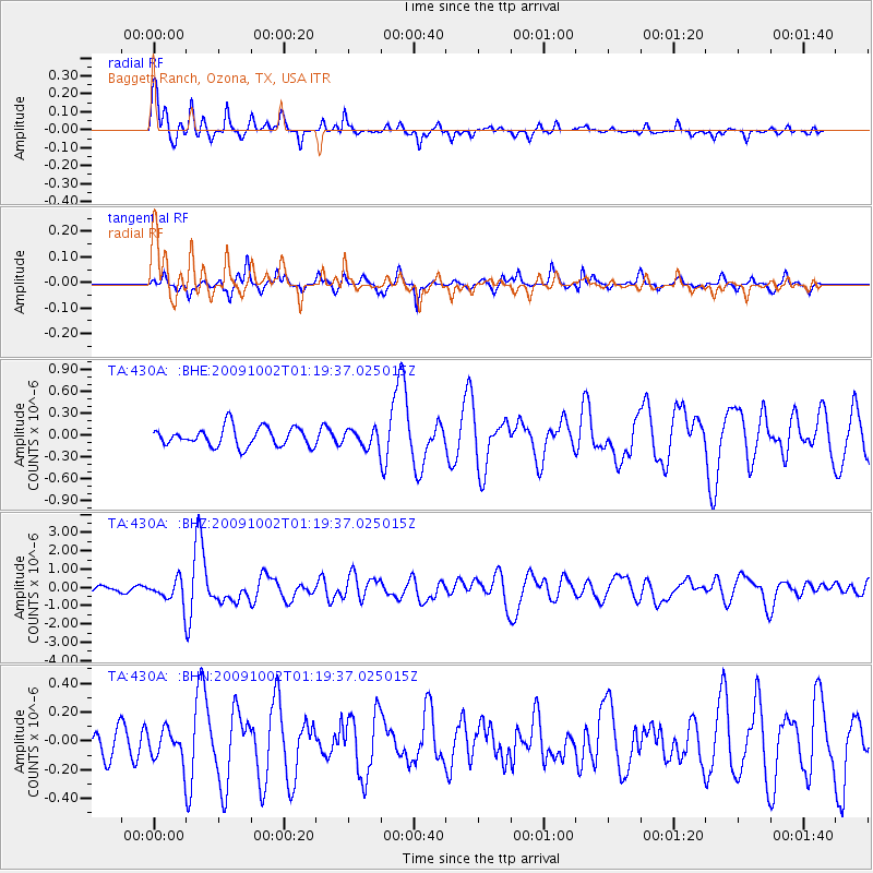
| Radial Match: |
88.41419 % |
| Radial Bump: |
279 |
| Transverse Match: |
69.04927 % |
| Transverse Bump: |
228 |
| SOD ConfigId: |
2622 |
| Insert Time: |
2010-03-05 23:28:47.228 +0000 |
| GWidth: |
2.5 |
| Max Bumps: |
400 |
| Tol: |
0.001 |
|
Signal To Noise
| Channel | StoN | STA | LTA |
| TA:430A: :BHZ:20091002T01:19:37.025015Z | 5.4682827 | 6.226397E-7 | 1.1386385E-7 |
| TA:430A: :BHN:20091002T01:19:37.025015Z | 0.71289515 | 1.06956655E-7 | 1.500314E-7 |
| TA:430A: :BHE:20091002T01:19:37.025015Z | 0.8922541 | 1.1601568E-7 | 1.3002537E-7 |
| Arrivals |
| Ps | 5.8 SECOND |
| PpPs | 17 SECOND |
| PsPs/PpSs | 23 SECOND |


