You are here: Home > Network List > TA - USArray Transportable Network (new EarthScope stations) Stations List
> Station 430A Baggett Ranch, Ozona, TX, USA > Earthquake Result Viewer
430A Baggett Ranch, Ozona, TX, USA - Earthquake Result Viewer
| Earthquake location: |
Southern Peru |
| Earthquake latitude/longitude: |
-15.0/-70.4 |
| Earthquake time(UTC): |
2009/07/12 (193) 06:12:47 GMT |
| Earthquake Depth: |
199 km |
| Earthquake Magnitude: |
5.7 MB, 6.1 MW, 6.1 MW |
| Earthquake Catalog/Contributor: |
WHDF/NEIC |
|
| Network: |
TA USArray Transportable Network (new EarthScope stations) |
| Station: |
430A Baggett Ranch, Ozona, TX, USA |
| Lat/Lon: |
30.79 N/101.24 W |
| Elevation: |
768 m |
|
| Distance: |
54.3 deg |
| Az: |
327.167 deg |
| Baz: |
142.503 deg |
| Ray Param: |
0.0648215 |
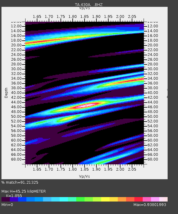
| Estimated Moho Depth: |
45.25 km |
| Estimated Crust Vp/Vs: |
1.86 |
| Assumed Crust Vp: |
6.38 km/s |
| Estimated Crust Vs: |
3.44 km/s |
| Estimated Crust Poisson's Ratio: |
0.30 |
|
| Radial Match: |
91.21325 % |
| Radial Bump: |
400 |
| Transverse Match: |
80.37334 % |
| Transverse Bump: |
400 |
| SOD ConfigId: |
2648 |
| Insert Time: |
2010-03-05 23:29:03.766 +0000 |
| GWidth: |
2.5 |
| Max Bumps: |
400 |
| Tol: |
0.001 |
|
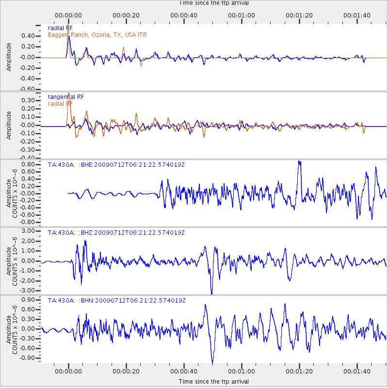
Signal To Noise
| Channel | StoN | STA | LTA |
| TA:430A: :BHZ:20090712T06:21:22.574019Z | 9.738768 | 9.2087026E-7 | 9.4557166E-8 |
| TA:430A: :BHN:20090712T06:21:22.574019Z | 2.9583921 | 1.8696963E-7 | 6.319974E-8 |
| TA:430A: :BHE:20090712T06:21:22.574019Z | 3.2126625 | 1.8038932E-7 | 5.614948E-8 |
| Arrivals |
| Ps | 6.4 SECOND |
| PpPs | 19 SECOND |
| PsPs/PpSs | 26 SECOND |


