You are here: Home > Network List > TA - USArray Transportable Network (new EarthScope stations) Stations List
> Station 430A Baggett Ranch, Ozona, TX, USA > Earthquake Result Viewer
430A Baggett Ranch, Ozona, TX, USA - Earthquake Result Viewer
| Earthquake location: |
Off Coast Of Ecuador |
| Earthquake latitude/longitude: |
1.4/-85.2 |
| Earthquake time(UTC): |
2009/05/10 (130) 01:16:06 GMT |
| Earthquake Depth: |
6.0 km |
| Earthquake Magnitude: |
5.5 MB, 5.7 MS, 6.1 MW, 6.1 MW |
| Earthquake Catalog/Contributor: |
WHDF/NEIC |
|
| Network: |
TA USArray Transportable Network (new EarthScope stations) |
| Station: |
430A Baggett Ranch, Ozona, TX, USA |
| Lat/Lon: |
30.79 N/101.24 W |
| Elevation: |
768 m |
|
| Distance: |
33.0 deg |
| Az: |
334.039 deg |
| Baz: |
149.434 deg |
| Ray Param: |
0.07843531 |
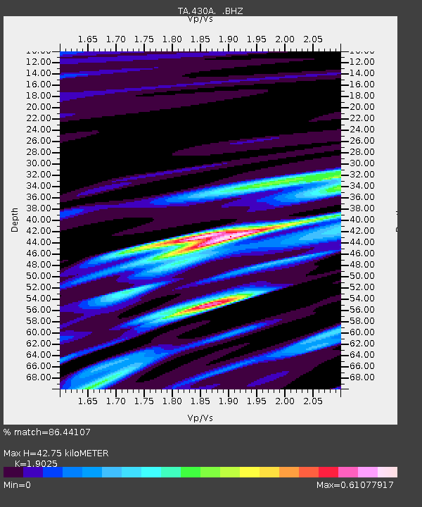
| Estimated Moho Depth: |
42.75 km |
| Estimated Crust Vp/Vs: |
1.90 |
| Assumed Crust Vp: |
6.38 km/s |
| Estimated Crust Vs: |
3.354 km/s |
| Estimated Crust Poisson's Ratio: |
0.31 |
|
| Radial Match: |
86.44107 % |
| Radial Bump: |
321 |
| Transverse Match: |
64.44962 % |
| Transverse Bump: |
361 |
| SOD ConfigId: |
2760 |
| Insert Time: |
2010-03-05 23:29:05.543 +0000 |
| GWidth: |
2.5 |
| Max Bumps: |
400 |
| Tol: |
0.001 |
|
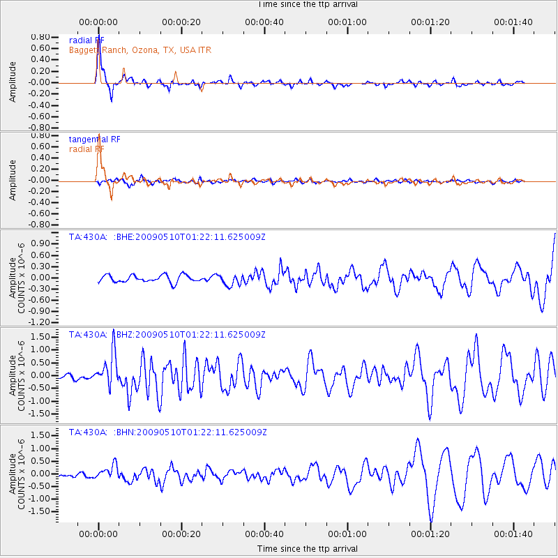
Signal To Noise
| Channel | StoN | STA | LTA |
| TA:430A: :BHZ:20090510T01:22:11.625009Z | 6.959643 | 6.704873E-7 | 9.633932E-8 |
| TA:430A: :BHN:20090510T01:22:11.625009Z | 3.0344987 | 2.8922136E-7 | 9.531109E-8 |
| TA:430A: :BHE:20090510T01:22:11.625009Z | 1.5526764 | 1.4827168E-7 | 9.5494265E-8 |
| Arrivals |
| Ps | 6.5 SECOND |
| PpPs | 18 SECOND |
| PsPs/PpSs | 25 SECOND |


