You are here: Home > Network List > CB - China National Seismic Network Stations List
> Station GYA Guiyang,Yunnan Province > Earthquake Result Viewer
GYA Guiyang,Yunnan Province - Earthquake Result Viewer
| Earthquake location: |
Southeastern Alaska |
| Earthquake latitude/longitude: |
59.9/-136.6 |
| Earthquake time(UTC): |
2017/05/01 (121) 12:31:53 GMT |
| Earthquake Depth: |
0.1 km |
| Earthquake Magnitude: |
6.5 Ml |
| Earthquake Catalog/Contributor: |
NEIC PDE/ak |
|
| Network: |
CB China National Seismic Network |
| Station: |
GYA Guiyang,Yunnan Province |
| Lat/Lon: |
26.46 N/106.66 E |
| Elevation: |
1162 m |
|
| Distance: |
79.7 deg |
| Az: |
305.565 deg |
| Baz: |
27.248 deg |
| Ray Param: |
0.04880315 |
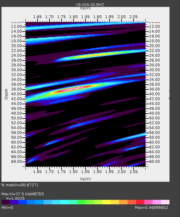
| Estimated Moho Depth: |
37.5 km |
| Estimated Crust Vp/Vs: |
1.80 |
| Assumed Crust Vp: |
6.113 km/s |
| Estimated Crust Vs: |
3.391 km/s |
| Estimated Crust Poisson's Ratio: |
0.28 |
|
| Radial Match: |
88.67271 % |
| Radial Bump: |
400 |
| Transverse Match: |
83.16719 % |
| Transverse Bump: |
400 |
| SOD ConfigId: |
11737051 |
| Insert Time: |
2019-04-27 06:18:28.929 +0000 |
| GWidth: |
2.5 |
| Max Bumps: |
400 |
| Tol: |
0.001 |
|

Signal To Noise
| Channel | StoN | STA | LTA |
| CB:GYA:00:BHZ:20170501T12:43:31.850015Z | 21.30895 | 1.8447514E-6 | 8.657167E-8 |
| CB:GYA:00:BHN:20170501T12:43:31.850015Z | 8.359039 | 4.0023946E-7 | 4.7881038E-8 |
| CB:GYA:00:BHE:20170501T12:43:31.850015Z | 6.05963 | 3.2729784E-7 | 5.4012848E-8 |
| Arrivals |
| Ps | 5.0 SECOND |
| PpPs | 17 SECOND |
| PsPs/PpSs | 22 SECOND |


