You are here: Home > Network List > TA - USArray Transportable Network (new EarthScope stations) Stations List
> Station 430A Baggett Ranch, Ozona, TX, USA > Earthquake Result Viewer
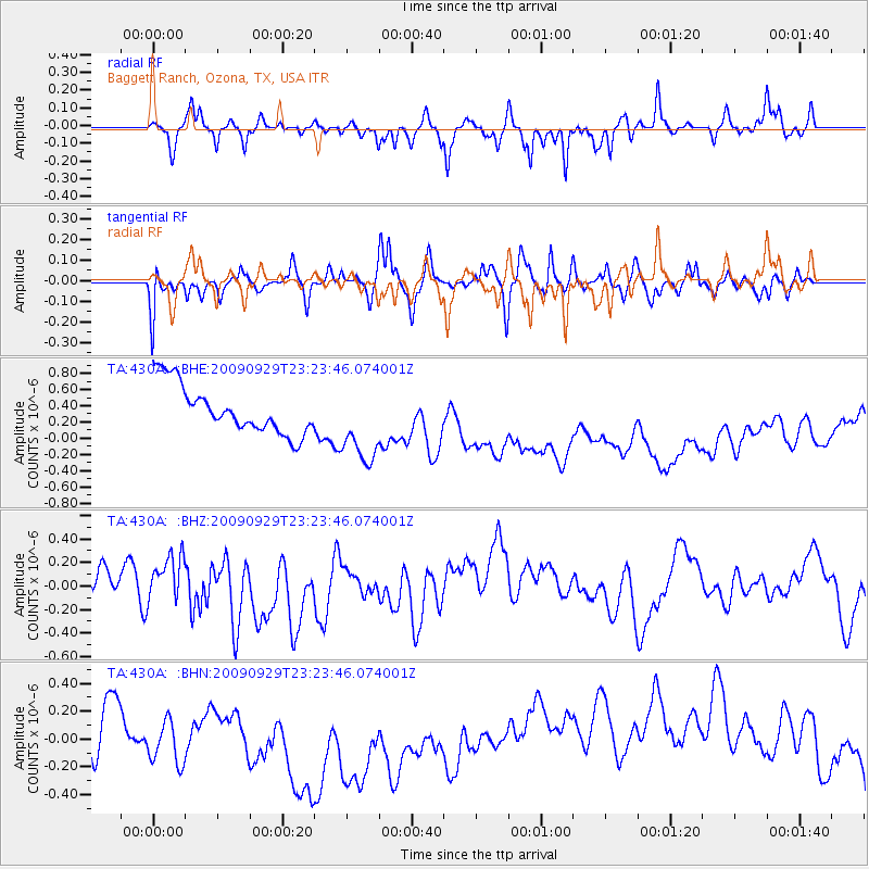
430A Baggett Ranch, Ozona, TX, USA - Earthquake Result Viewer
*The percent match for this event was below the threshold and hence no stack was calculated.
| Earthquake location: |
Tonga Islands |
| Earthquake latitude/longitude: |
-15.6/-173.4 |
| Earthquake time(UTC): |
2009/09/29 (272) 23:11:51 GMT |
| Earthquake Depth: |
10 km |
| Earthquake Magnitude: |
5.5 MB |
| Earthquake Catalog/Contributor: |
WHDF/NEIC |
|
| Network: |
TA USArray Transportable Network (new EarthScope stations) |
| Station: |
430A Baggett Ranch, Ozona, TX, USA |
| Lat/Lon: |
30.79 N/101.24 W |
| Elevation: |
768 m |
|
| Distance: |
83.2 deg |
| Az: |
55.576 deg |
| Baz: |
247.461 deg |
| Ray Param: |
$rayparam |
*The percent match for this event was below the threshold and hence was not used in the summary stack. |
|
| Radial Match: |
41.959316 % |
| Radial Bump: |
271 |
| Transverse Match: |
43.22598 % |
| Transverse Bump: |
360 |
| SOD ConfigId: |
2622 |
| Insert Time: |
2010-03-05 23:29:18.501 +0000 |
| GWidth: |
2.5 |
| Max Bumps: |
400 |
| Tol: |
0.001 |
|
Signal To Noise
| Channel | StoN | STA | LTA |
| TA:430A: :BHZ:20090929T23:23:46.074001Z | 0.6504121 | 2.7577968E-7 | 4.2400762E-7 |
| TA:430A: :BHN:20090929T23:23:46.074001Z | 1.3949196 | 3.2769537E-7 | 2.3492062E-7 |
| TA:430A: :BHE:20090929T23:23:46.074001Z | 1.6596797 | 4.96021E-7 | 2.988655E-7 |
| Arrivals |
| Ps | |
| PpPs | |
| PsPs/PpSs | |


