You are here: Home > Network List > GB - Great Britain Seismograph Network Stations List
> Station CWF CHARNWOOD FOREST, ENGLAND > Earthquake Result Viewer
CWF CHARNWOOD FOREST, ENGLAND - Earthquake Result Viewer
| Earthquake location: |
Southeastern Alaska |
| Earthquake latitude/longitude: |
59.9/-136.6 |
| Earthquake time(UTC): |
2017/05/01 (121) 12:31:53 GMT |
| Earthquake Depth: |
0.1 km |
| Earthquake Magnitude: |
6.5 Ml |
| Earthquake Catalog/Contributor: |
NEIC PDE/ak |
|
| Network: |
GB Great Britain Seismograph Network |
| Station: |
CWF CHARNWOOD FOREST, ENGLAND |
| Lat/Lon: |
52.74 N/1.31 W |
| Elevation: |
203 m |
|
| Distance: |
62.1 deg |
| Az: |
28.961 deg |
| Baz: |
336.31 deg |
| Ray Param: |
0.060456645 |
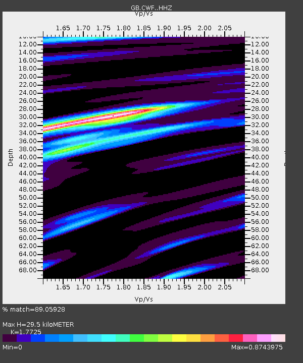
| Estimated Moho Depth: |
29.5 km |
| Estimated Crust Vp/Vs: |
1.77 |
| Assumed Crust Vp: |
6.276 km/s |
| Estimated Crust Vs: |
3.541 km/s |
| Estimated Crust Poisson's Ratio: |
0.27 |
|
| Radial Match: |
89.05928 % |
| Radial Bump: |
330 |
| Transverse Match: |
71.40383 % |
| Transverse Bump: |
384 |
| SOD ConfigId: |
11737051 |
| Insert Time: |
2019-04-27 06:19:52.574 +0000 |
| GWidth: |
2.5 |
| Max Bumps: |
400 |
| Tol: |
0.001 |
|

Signal To Noise
| Channel | StoN | STA | LTA |
| GB:CWF: :HHZ:20170501T12:41:45.949991Z | 11.057359 | 4.830223E-6 | 4.3683335E-7 |
| GB:CWF: :HHN:20170501T12:41:45.949991Z | 8.366803 | 2.1335902E-6 | 2.5500663E-7 |
| GB:CWF: :HHE:20170501T12:41:45.949991Z | 3.6632497 | 1.1312983E-6 | 3.0882367E-7 |
| Arrivals |
| Ps | 3.8 SECOND |
| PpPs | 12 SECOND |
| PsPs/PpSs | 16 SECOND |


