You are here: Home > Network List > GM - US Geological Survey Networks Stations List
> Station IWM01 Jericho 2M Well Monitoring Station > Earthquake Result Viewer
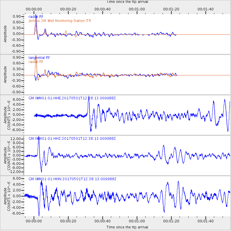
IWM01 Jericho 2M Well Monitoring Station - Earthquake Result Viewer
*The percent match for this event was below the threshold and hence no stack was calculated.
| Earthquake location: |
Southeastern Alaska |
| Earthquake latitude/longitude: |
59.9/-136.6 |
| Earthquake time(UTC): |
2017/05/01 (121) 12:31:53 GMT |
| Earthquake Depth: |
0.1 km |
| Earthquake Magnitude: |
6.5 Ml |
| Earthquake Catalog/Contributor: |
NEIC PDE/ak |
|
| Network: |
GM US Geological Survey Networks |
| Station: |
IWM01 Jericho 2M Well Monitoring Station |
| Lat/Lon: |
36.73 N/96.53 W |
| Elevation: |
328 m |
|
| Distance: |
34.5 deg |
| Az: |
114.059 deg |
| Baz: |
325.009 deg |
| Ray Param: |
$rayparam |
*The percent match for this event was below the threshold and hence was not used in the summary stack. |
|
| Radial Match: |
83.20651 % |
| Radial Bump: |
297 |
| Transverse Match: |
73.10943 % |
| Transverse Bump: |
400 |
| SOD ConfigId: |
11737051 |
| Insert Time: |
2019-04-27 06:20:23.895 +0000 |
| GWidth: |
2.5 |
| Max Bumps: |
400 |
| Tol: |
0.001 |
|
Signal To Noise
| Channel | StoN | STA | LTA |
| GM:IWM01:01:HHZ:20170501T12:38:13.009988Z | 28.011377 | 5.9309277E-6 | 2.1173281E-7 |
| GM:IWM01:01:HHN:20170501T12:38:13.009988Z | 5.634142 | 2.884024E-6 | 5.1188346E-7 |
| GM:IWM01:01:HHE:20170501T12:38:13.009988Z | 11.856698 | 3.2141795E-6 | 2.7108555E-7 |
| Arrivals |
| Ps | |
| PpPs | |
| PsPs/PpSs | |


