You are here: Home > Network List > JP - Japan Meteorological Agency Seismic Network Stations List
> Station JSD Sado > Earthquake Result Viewer
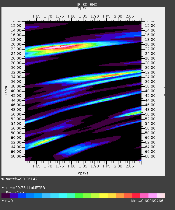
JSD Sado - Earthquake Result Viewer
| Earthquake location: |
Southeastern Alaska |
| Earthquake latitude/longitude: |
59.9/-136.6 |
| Earthquake time(UTC): |
2017/05/01 (121) 12:31:53 GMT |
| Earthquake Depth: |
0.1 km |
| Earthquake Magnitude: |
6.5 Ml |
| Earthquake Catalog/Contributor: |
NEIC PDE/ak |
|
| Network: |
JP Japan Meteorological Agency Seismic Network |
| Station: |
JSD Sado |
| Lat/Lon: |
38.04 N/138.26 E |
| Elevation: |
146 m |
|
| Distance: |
55.7 deg |
| Az: |
287.781 deg |
| Baz: |
37.479 deg |
| Ray Param: |
0.06463534 |
| Estimated Moho Depth: |
20.75 km |
| Estimated Crust Vp/Vs: |
1.75 |
| Assumed Crust Vp: |
6.183 km/s |
| Estimated Crust Vs: |
3.528 km/s |
| Estimated Crust Poisson's Ratio: |
0.26 |
|
| Radial Match: |
90.26147 % |
| Radial Bump: |
400 |
| Transverse Match: |
89.034424 % |
| Transverse Bump: |
400 |
| SOD ConfigId: |
11737051 |
| Insert Time: |
2019-04-27 06:21:05.422 +0000 |
| GWidth: |
2.5 |
| Max Bumps: |
400 |
| Tol: |
0.001 |
|

Signal To Noise
| Channel | StoN | STA | LTA |
| JP:JSD: :BHZ:20170501T12:41:00.850015Z | 17.40912 | 2.7012798E-6 | 1.5516464E-7 |
| JP:JSD: :BHN:20170501T12:41:00.850015Z | 4.3862305 | 4.935174E-7 | 1.1251515E-7 |
| JP:JSD: :BHE:20170501T12:41:00.850015Z | 3.9173806 | 6.7349333E-7 | 1.7192441E-7 |
| Arrivals |
| Ps | 2.7 SECOND |
| PpPs | 8.8 SECOND |
| PsPs/PpSs | 11 SECOND |


