You are here: Home > Network List > TA - USArray Transportable Network (new EarthScope stations) Stations List
> Station 430A Baggett Ranch, Ozona, TX, USA > Earthquake Result Viewer
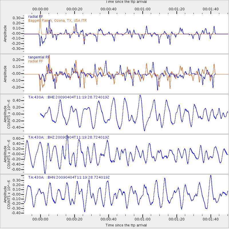
430A Baggett Ranch, Ozona, TX, USA - Earthquake Result Viewer
*The percent match for this event was below the threshold and hence no stack was calculated.
| Earthquake location: |
Tonga Islands Region |
| Earthquake latitude/longitude: |
-22.5/-174.7 |
| Earthquake time(UTC): |
2009/04/04 (094) 11:07:12 GMT |
| Earthquake Depth: |
35 km |
| Earthquake Magnitude: |
5.5 MB, 5.4 MS, 5.5 MW, 5.5 MW |
| Earthquake Catalog/Contributor: |
WHDF/NEIC |
|
| Network: |
TA USArray Transportable Network (new EarthScope stations) |
| Station: |
430A Baggett Ranch, Ozona, TX, USA |
| Lat/Lon: |
30.79 N/101.24 W |
| Elevation: |
768 m |
|
| Distance: |
88.1 deg |
| Az: |
55.615 deg |
| Baz: |
242.465 deg |
| Ray Param: |
$rayparam |
*The percent match for this event was below the threshold and hence was not used in the summary stack. |
|
| Radial Match: |
72.88281 % |
| Radial Bump: |
364 |
| Transverse Match: |
65.238785 % |
| Transverse Bump: |
297 |
| SOD ConfigId: |
2658 |
| Insert Time: |
2010-03-05 23:29:39.150 +0000 |
| GWidth: |
2.5 |
| Max Bumps: |
400 |
| Tol: |
0.001 |
|
Signal To Noise
| Channel | StoN | STA | LTA |
| TA:430A: :BHZ:20090404T11:19:28.724019Z | 2.250059 | 4.1732E-7 | 1.854707E-7 |
| TA:430A: :BHN:20090404T11:19:28.724019Z | 0.97752786 | 1.1034657E-7 | 1.1288329E-7 |
| TA:430A: :BHE:20090404T11:19:28.724019Z | 1.5349561 | 2.860786E-7 | 1.8637576E-7 |
| Arrivals |
| Ps | |
| PpPs | |
| PsPs/PpSs | |


