You are here: Home > Network List > WY - Yellowstone Wyoming Seismic Network Stations List
> Station YMP Mirror Lake Plateau, YNP, WY, USA > Earthquake Result Viewer
YMP Mirror Lake Plateau, YNP, WY, USA - Earthquake Result Viewer
| Earthquake location: |
Peru-Brazil Border Region |
| Earthquake latitude/longitude: |
-9.2/-71.3 |
| Earthquake time(UTC): |
2015/11/26 (330) 05:45:18 GMT |
| Earthquake Depth: |
604 km |
| Earthquake Magnitude: |
6.4 MWP |
| Earthquake Catalog/Contributor: |
NEIC PDE/NEIC COMCAT |
|
| Network: |
WY Yellowstone Wyoming Seismic Network |
| Station: |
YMP Mirror Lake Plateau, YNP, WY, USA |
| Lat/Lon: |
44.74 N/110.16 W |
| Elevation: |
2774 m |
|
| Distance: |
64.2 deg |
| Az: |
330.192 deg |
| Baz: |
136.48 deg |
| Ray Param: |
0.056811463 |
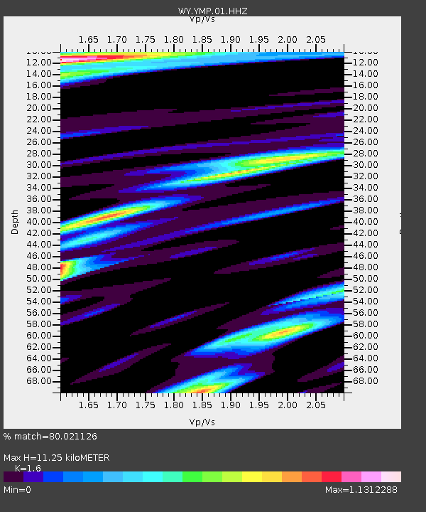
| Estimated Moho Depth: |
11.25 km |
| Estimated Crust Vp/Vs: |
1.60 |
| Assumed Crust Vp: |
6.35 km/s |
| Estimated Crust Vs: |
3.969 km/s |
| Estimated Crust Poisson's Ratio: |
0.18 |
|
| Radial Match: |
80.021126 % |
| Radial Bump: |
400 |
| Transverse Match: |
79.808945 % |
| Transverse Bump: |
400 |
| SOD ConfigId: |
1259291 |
| Insert Time: |
2015-12-10 06:10:58.647 +0000 |
| GWidth: |
2.5 |
| Max Bumps: |
400 |
| Tol: |
0.001 |
|

Signal To Noise
| Channel | StoN | STA | LTA |
| WY:YMP:01:HHZ:20151126T05:54:24.558Z | 18.876154 | 9.6418034E-8 | 5.107928E-9 |
| WY:YMP:01:HHN:20151126T05:54:24.558Z | 5.850988 | 2.7126433E-8 | 4.636214E-9 |
| WY:YMP:01:HHE:20151126T05:54:24.558Z | 9.736336 | 6.73605E-8 | 6.9184654E-9 |
| Arrivals |
| Ps | 1.1 SECOND |
| PpPs | 4.4 SECOND |
| PsPs/PpSs | 5.5 SECOND |


