You are here: Home > Network List > LD - Lamont-Doherty Cooperative Seismographic Network Stations List
> Station BRNJ Basking Ridge, New Jersey > Earthquake Result Viewer
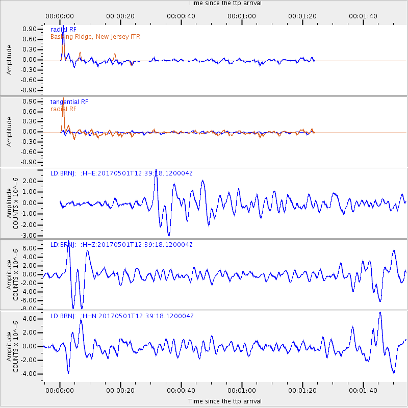
BRNJ Basking Ridge, New Jersey - Earthquake Result Viewer
*The percent match for this event was below the threshold and hence no stack was calculated.
| Earthquake location: |
Southeastern Alaska |
| Earthquake latitude/longitude: |
59.9/-136.6 |
| Earthquake time(UTC): |
2017/05/01 (121) 12:31:53 GMT |
| Earthquake Depth: |
0.1 km |
| Earthquake Magnitude: |
6.5 Ml |
| Earthquake Catalog/Contributor: |
NEIC PDE/ak |
|
| Network: |
LD Lamont-Doherty Cooperative Seismographic Network |
| Station: |
BRNJ Basking Ridge, New Jersey |
| Lat/Lon: |
40.68 N/74.57 W |
| Elevation: |
50 m |
|
| Distance: |
42.2 deg |
| Az: |
88.35 deg |
| Baz: |
318.458 deg |
| Ray Param: |
$rayparam |
*The percent match for this event was below the threshold and hence was not used in the summary stack. |
|
| Radial Match: |
90.19779 % |
| Radial Bump: |
306 |
| Transverse Match: |
64.34551 % |
| Transverse Bump: |
382 |
| SOD ConfigId: |
11737051 |
| Insert Time: |
2019-04-27 06:21:40.434 +0000 |
| GWidth: |
2.5 |
| Max Bumps: |
400 |
| Tol: |
0.001 |
|
Signal To Noise
| Channel | StoN | STA | LTA |
| LD:BRNJ: :HHZ:20170501T12:39:18.120004Z | 13.828587 | 4.0629297E-6 | 2.9380655E-7 |
| LD:BRNJ: :HHN:20170501T12:39:18.120004Z | 9.836171 | 1.5666926E-6 | 1.5927871E-7 |
| LD:BRNJ: :HHE:20170501T12:39:18.120004Z | 8.910126 | 1.4004295E-6 | 1.571728E-7 |
| Arrivals |
| Ps | |
| PpPs | |
| PsPs/PpSs | |


